Blog - For The Record — NYC Department of Records & Information Services

Michael Lorenzini

On the Scene: Eugene de Salignac’s Photographs of Traffic Safety

BPS 8214: Williamsburg Bridge, view showing [electric] auto truck, south roadway between Bedford and Driggs Avenue, Brooklyn, June 5, 1923.

Eugene de Salignac served as Photographer for the Department of Plant & Structures (originally the Department of Bridges) from 1906 to 1934. During this time, the agency took on many of the functions that would later be taken over by the Department of Transportation and the MTA. When I wrote New York Rises: Photographs by Eugene de Salignac (Aperture 2007), I included a chapter “Accidents.” In it I wrote: “An important part of de Salignac’s job seems to have been photographing accidents that occurred on or under New York bridges or that involved city-operated bus lines. These were documents made for the City’s Corporation Counsel to use in possible legal cases or to show needed repairs to damaged property. Often de Salignac arrived at the scene within minutes of the incident before passengers had even been evacuated.” What I did not cover in the book were the ways that the Plant & Structures agency tried to address the growing problem of traffic safety. This week’s “For the Record” takes another look at these photos.

BPS 8215: Williamsburg Bridge, view showing [electric] auto truck, south roadway between Bedford and Driggs Avenue, Brooklyn, June 5, 1923.

BPS III 2022: Manhattan Bridge, view showing auto damaged by accident, February 23, 1924.

BPS 5880: Park Circle stage line accident 11:30 a.m., close view, December 6, 1919.

BPS 4974: Lenox Avenue Bridge 145th Street showing accident to auto, Bronx approach north side, July 10, 1917.

BPS 7226: Vernon Avenue Bridge view showing accident to auto truck, May 15, 1922.

BPS IV 1874: Queensboro Bridge, Queens view showing automobile accident, June 11, 1920.

BPS III 1848: Manhattan Bridge view showing auto [taxi] damaged by accident in roadway north side at point 51 looking east from roadway, main span, October 23, 1918.

BPS III 1295: Manhattan Bridge Brooklyn showing accident, J. Ruppert auto truck from subway wall, November 13, 1913. This strange looking vehicle is another electric delivery truck, which were quite common in the City in the early part of the 20th Century.

Nineteenth-century New York was not without traffic accidents. People were struck and killed by horse-drawn carriages and trolley cars with some regularity, and the first recorded automobile accident was on May 30, 1896. However, the early twentieth century saw all manner of new and faster vehicles on the streets of New York, both gas-powered and electric. The introduction of the Model T in 1908 made gas-powered cars ubiquitous and by the nineteen-teens they dominated the roadways. With little in the way of traffic signs or rules of the road, accidents were inevitable. Early cars were not equipped with safety features and accidents were often fatal. In 1913, The New York Times (in an article entitled “Death Harvest”) reported that from 1911 to 1912 the number of people killed from horse-drawn vehicles decreased from 211 to 177, and from streetcars from 148 to 134, but automobile fatalities had risen from 112 to 221. Almost all were pedestrians. In comparison, in January of this year, the Times reported that 2024 had experienced a surge in pedestrian deaths, which had jumped from 101 in 2023 to 119.

BPS IV 2577: Queensboro Bridge showing accident to auto, May 22, 1933.

BPS 7267: 42nd Street and Fifth Avenue view showing Plants & Structures Commissioner Grover Whalen at grand opening for new signal tower for Police Department, June 16, 1922.

BPS 7524: 42nd Street and Fifth Avenue, erecting signal tower, Police Department, December 13, 1922. In the background can be seen the original 1920 signal tower. The new tower is flat on the truck.

BPS 7524: 42nd Street and Fifth Avenue, erecting signal tower, Police Department, December 13, 1922. The new bronze signal tower, designed by Joseph H. Freedlander, being hoisted into place.

BPS 8435: Traffic Tower 42nd Street and Fifth Avenue view of tower, October 18, 1923.

BPS 8436: Traffic Tower 42nd Street and Fifth Avenue view of tower “close,” October 18, 1923.

The first electric traffic lights came about in the nineteen teens, but New York City did not get one until 1920. It was a tall tower with a wooden shed from which a police officer manually controlled the lights. It was installed at Fifth Avenue and 42nd Street, under the oversight of Dr. John F. Harriss, the City’s first traffic commissioner. A typed report from 1953 in the Municipal Library “vertical files” states that “The first traffic towers were in use March 11, 1920, at 34th, 38th, 42nd, 50th and 57th Streets and were painted white with black trim. These towers were replaced by more elaborate ones provided by the Fifth Avenue Association in 1922-3.” A police patrolman in each tower manually operated the signals, though in 1926, a system was installed so that one operator could control the signals in all the towers.

In 1924, the City started installing more towers, mostly at busy intersections in Brooklyn. The first independent traffic lights appeared in 1928, marking the end for the system of traffic towers. A 1928 City Record report by the Department of Plant & Structures notes extensive contracts for the installation of lights: 22 on 10th Avenue and Amsterdam Avenue, 17 on 4th Avenue in Brooklyn, 19 in Queens, 14 along 125th Street, and a smattering in the Bronx. Lights were not yet installed on Staten Island. A completely automated system for Manhattan went into operation on March 8, 1929, and on May 7th the demolition of the old towers began.

BPS 8949: Ceremony at opening of traffic towers Grant Square, Brooklyn, June 17, 1924.

BPS 9018: Police traffic light at Broadway and Vesey Street, July 9, 1924.

BPS 9019: [Crowd at opening of] Police traffic light at Broadway and Vesey Street, July 9, 1924.

Although they were short-lived, the traffic towers had been met with much fanfare when they opened. De Salignac seems to have dashed between many on the same night more than once. His photographs of these towers, all similar, but all different, bring to mind the images of water towers and other industrial structures taken by the conceptual German photographers Bernd and Hilla Becher in the 1960s and 1970s. Enjoy.

Above: Traffic towers along Bedford Avenue, Brooklyn, May 16, 1924.

Above: Traffic Tower Lights, March 5, 1926. Location unknown.

BPS 10053: Traffic tower lights, March 5, 1926.

Above, left and center: Manhattan Bridge showing signal tower, January 15, 1924.

Right: Manhattan Bridge, view showing signal tower Manhattan end of new roadway where auto collided, February 23, 1924.

BPS 11860: Traffic lights, Ocean Avenue and Caton Avenue, August 4, 1928.

BPS 11741: Traffic light and post damaged at 34th Street and Lexington Avenue, May 17, 1928.


All photographs above by Eugene de Salignac, Department of Bridges/Plant & Structures Collection, NYC Municipal Archives.

Sources:

In 2014, Christopher Gray (a cherished and missed friend of this agency) wrote about the history of New York’s Traffic lights in his popular New York Times “Streetscapes” column:

https://www.nytimes.com/2014/05/18/realestate/a-history-of-new-york-traffic-lights.html

https://www.nytimes.com/2025/01/01/nyregion/walkable-new-york-city-became-deadlier-for-pedestrians-in-2024.html

For more on the Bechers: https://spruethmagers.com/artists/bernd-hilla-becher/

Herman Melville’s New York

Map bounded by Bowling Green Row, Marketfield Street, Beaver Street, William Street, Old Slip, South Street, Whitehall Street, State Street, Plate 1, 1852. William Perris, civil engineer and surveyor. Courtesy New York Public Library.

The name Herman Melville may conjure visions of adventures on the high seas, the “watery part of the world” in the author’s parlance, but Melville was very much a New Yorker for most of his life. He was born Herman Melvill in 1819 in a rooming house at 6 Pearl Street, the third of eight children. The house is long gone, but an illustration of Pearl Street found in D.T. Valentine’s manuals shows the house in 1858. His mother, Maria Gansevoort, had him baptized in the Calvinist Dutch Reformed church she attended. The Gansevoorts were a long-established Dutch family and Maria’s father, Peter Gansevoort, had been a decorated colonel in the Continental Army. In 1777, Peter Gansevoort at the age of only 28, took command of Fort Stanwix and led it through a siege by British forces. It was the only American fort not to surrender to the British during the American Revolution. In 1812, a new fort was named in honor of him, at the foot of today’s Gansevoort Street.

View of Pearl Street looking from State Street, 1858. A. Weingartner’s Lithography, for D.T. Valentine's Manual of 1859. NYC Municipal Library. Herman Melville was born in a rooming house at 6 Pearl Street in 1819, the third of eight children. It still stood in 1858, the 2nd house from the right.

Meville’s father, Alvin Melvill (the family added the “e” after Alvin’s death), was a merchant in the bustling New York-to-Europe trade boom following the War of 1812. Mercantile New York offered great rewards and great risk, and the family fortunes soon rose and fell. Alvin borrowed money heavily from the Gansevoorts for his trading ventures and to raise the family’s standard of living. In quick succession he moved his family to their own house at 55 Cortlandt Street in 1821, then to 33 Bleecker Street in 1824, and then to the fashionable address of 675 Broadway in 1828. There is scant record of this house, but it probably resembled the Merchant’s House Museum, which still stands nearby on East 4th Street. It is hard to over-estimate the exclusiveness of the neighborhood at this time, centered around Lafayette Street, one block over. Their neighbors in the 9th Ward would have included Stuyvesants, Astors, Roosevelts, Delanos, and Vanderbilts.

Record of Assessments, 9th Ward, 1829. NYC Municipal Archives. This assessment (which incorrectly has Allen instead of Alvin Melvill) shows that Alvin did not own his house at 675 Broadway, it was his personal estate that was valued at $4,000. Alvin was living above his means to be close to New York’s gentry.

Melvill was very devoted to his children and especially concerned with giving the boys a good education, but he was financially over-extended—the household was lavish, and they employed many servants. In 1825 Herman attended the New York Male High School and then in 1829 he transferred to the more prestigious Columbia Grammar and Preparatory School. After the last of Herman’s seven siblings was born in 1830, the Gansevoorts cut off Melvill financially. He quickly went bankrupt and was briefly placed in a debtor’s prison. Going into the fur business, he relocated the family to Albany. Enrolled in the Albany Academy, Herman was praised as a bright scholar, but he withdrew in the fall of 1831, perhaps because of the family finances.

South from Maiden Lane, 1828. George Hayward lithographer, for D.T. Valentine’s Manual of 1854. NYC Municipal Library. 

Added to these reminiscences my father, now dead, had several times crossed the Atlantic on business affairs, for he had been an importer in Broad-street. And of winter evenings in New York, by the well-remembered sea-coal fire in old Greenwich-street, he used to tell my brother and me of the monstrous waves at sea, mountain high; of the masts bending like twigs...
— Herman Melville, Redburn

In December 1831, Alvin fell ill with a high fever after traveling in an open carriage during a winter storm and died on January 28, 1832. His death again threw the family into a desperate situation. Oldest son Gansevoort Melvill took over the fur business and Herman, age 14, found a job as a bank clerk. In 1834, Gansevoort took him from the bank to run his fur store, as he could not afford staff, but by 1835 Herman was again able to return to his studies of the classics. The Panic of 1837 shattered the family’s fortunes once again, and Gansevoort filed for bankruptcy. He moved back to New York City to study law and Herman took a job as a schoolteacher for a semester. By 1839, Herman, always entranced by his father’s tales of Europe and stories from relatives who had taken to the sea, decided to ship out. He signed on to the St. Lawrence, a merchant ship out of New York, as a “boy” (an untrained hand) for a voyage to Liverpool and back. This brief introduction to the sea and the experience of the slums of 19th-century England would become the basis of his fourth novel, Redburn: His First Voyage.

Coffee House Slip and New York Coffee House. George Hayward, lithographer for D.T. Valentine’s Manual of 1856. NYC Municipal Library. “...somewhere near ranges of grim-looking warehouses, with rusty iron doors and shutters, and tiled roofs; and old anchors and chain-cables piled on the walk. Old-fashioned coffee-houses, also, much abound in that neighborhood, with sun-burnt sea-captains going in and out, smoking cigars, and talking about Havana, London, and Calcutta.” -Herman Melville, Redburn

Upon his return, Herman again tried teaching but left when the school failed to pay his salary. His eyes turned to the sea once more. Gansevoort suggested he try his hand on a whaler and took him to New Bedford. There they found a whaling boat, the Acushnet, that would take him on as a green hand. They set sail on January 3, 1841, for what could be a four-year voyage. It was not entirely unusual for a young middle-class American man to go to sea and Melville might have been inspired by the memoir Two Years Before the Mast, by Richard Henry Dana, which was published in 1840. After hunting whales in the Bahamas and docking in Rio de Janeiro, they rounded Cape Horn and explored the South Pacific. Off the coast of Chile, they met up with a boat from Nantucket, where William Henry Chase gave Melville a copy of his father Owen’s account of the sinking of the ship Essex by a sperm whale.

Peck Slip, New York, 1850. George Hayward lithographer, for D.T. Valentine’s Manual of 1857. NYC Municipal Library. 

“Circumambulate the city of a dreamy Sabbath afternoon. Go from Corlears Hook to Coenties Slip, and from thence, by Whitehall, northward. What do you see? – Posted like silent sentinels all around the town, stand thousands upon thousands of mortal men fixed in ocean reveries. Some leaning against the spiles; some seated upon the pier-heads; some looking over the bulwarks of ships from China; some high aloft in the rigging, as if striving to get a still better seaward peep.”
— Herman Melville, Moby Dick

By the summer of 1842, Melville had tired of the whaling life, and he jumped ship in the Marquesas Islands. For four weeks he lived with a tribe in the Typee Valley on the island of Nukahiva just as it was falling under French rule. The Nuka Hiva still practiced cannibalism, but they treated Melville warmly and he was fascinated by their customs including communal ownership of property. Melville left the island on another whaling boat out of Australia but was thrown in jail in Tahiti for his role in a mutiny. He escaped in short order and wandered the Tahitian islands as a beachcomber until climbing aboard another whaler for a six-month cruise that ended in the Hawaii Islands. There he signed onto a US Navy ship that rounded the Horn again and returned him to Boston in 1844.

He came home bubbling with stories and a changed man. An educated young man from New York’s genteel classes, he had lived and worked amongst common seamen, from all races and parts of the globe, had lived amongst the people of Polynesia and had seen what colonization was doing to their cultures. At the urging of his family, he started writing. He stretched his month on Nukahiva into Typee: A Peep at Polynesian Life. Although presented as a true memoir, in his romantic retelling the narrator spends four months amongst the cannibals. Gansevoort Melville, by this time a successful orator and lawyer, was on his way to London in the diplomatic service. On the advice of a literary agent, he took Herman’s manuscript to London and arranged for the publication of simultaneous English and American editions of the book in early 1846. Herman Melville became an overnight literary sensation, but his success was soured by the sudden death of Gansevoort in London. Their brother Allen, who had worked with Gansevoort in their firm at 16 Pine Street, now took over as his literary agent.

Record of Assessments, 17th Ward, 1848. NYC Municipal Archives. Herman Melville was able to purchase his and Lizzie’s first house at 103 Fourth Avenue with the proceeds from his first two books. 

In 1847, Melville published a sequel, Omoo, which did well enough that he felt confident to marry Elizabeth Shaw, daughter of a prominent Massachusetts Judge, Lemuel Shaw. They started their marriage in New York City, in a house he purchased at 103 Fourth Avenue, valued at $6,000. But after a series of literary gatherings in Pittsfield, Massachusetts with Nathaniel Hawthorne and Oliver Wendell Holmes, amongst others, they borrowed money from Judge Shaw in 1850 to build their own house there, Arrowhead. By 1850, Melville was already at work on his magnum opus Moby Dick, which he finished at Arrowhead and published in 1851. Hawthorne thought the book showed depths to Melville’s writing not previously displayed, but most reviewers were unkind, and the book was a commercial failure. After his next book Pierre again left reviewers perplexed, some began to question his sanity. After more commercial and critical failures, he published his final book, The Confidence-Man, in 1857 and took off for a tour of Europe and the Holy Land. On his return he tried the lecture circuit and started writing poetry. Finally, in 1863 he swapped his Pittsfield house for his brother’s house at 104 East 26th Street and the Melvilles returned to New York for good.

Fort Gansevoort or old White Fort. George Hayward lithographer, for D.T. Valentine’s Manual of 1850. NYC Municipal Library. Fort Gansevoort, named after Melville’s maternal grand-father Peter Gansevoort, was located by the Hudson River where the Whitney Museum now sits.

In 1866 he found a government job as a customs inspector. Stationed at a dock at the end of Gansevoort Street, he stayed for 19 years, perhaps protected in his position by an admirer of his writing, future president Chester A. Arthur, then a customs official. Melville was honest in his job but suffered from both physical and mental ailments. He had nervous breakdowns, drank heavily, and may have been abusive to his wife Lizzie. In May 1867, Lizzie’s brother arranged for her to leave Melville, but she refused. In September, their son Malcolm, aged 18, went to his bedroom after quarreling with his father and shot himself in the head. Although some contemporaneous accounts reported the death as accidental, the coroner inquest ruled it a suicide. The Melvilles somehow moved on.

Death certificate for Malcolm Melville, 1867. NYC Municipal Archives.

Herman Melville outlived all but one of his siblings. His brother Allan died in 1872, but he would visit with his youngest brother Thomas, a retired ship captain who was now the Governor of the Seaman’s Snug Harbor in Staten Island. Thomas died in 1884, their sister Frances the following year. Around this time, Lizzie received enough of an inheritance that Herman was able finally to retire in 1886. That same year, their remaining son Stanwix died of tuberculosis in San Francisco.

1890 Police Census, 104 E. 26th Street, 11th AD, First ED. NYC Municipal Archives. Herman Melville is shown living with his daughter Elizabeth “Bessie” Melville, wife Elizabeth (curiously called here Emilie although she was known by Lizzie), and presumably an Irish maid, Mary Brennan. Even more curious are the ages given of the occupants, in 1890 Melville would have been 71, not 59 and the rest of the ages of the Melville household all seem to be from ca. 1880 too.

Melville may have found some kind of peace in his final years. He collected artwork, an interest since childhood, visited book shops and joined the New York Society Library. He remained somewhat detached from the world. He apparently never voted, there being no record of him in voter registration books in the Municipal Archives. He showed up in the 1890 census living at home with his wife and their daughter Elizabeth (Bessie), and a single maid. In July 1891, he saw a doctor for trouble with his heart. He died of a heart attack on September 28, 1891, and was buried in Woodlawn Cemetery in the Bronx. His wife was buried beside him in 1905.

Contrary to some popular belief, the New York Times obituary did not misspell his name, it misspelled the name of what became his most famous book. It reads in its entirety: “Herman Melville died yesterday at his residence, 104 East Twenty-sixth Street, this city, of heart failure, aged seventy-two. He was the author of Typee, Omoo, Mobie Dick, and other sea-faring tales, written in earlier years. He leaves a wife and two daughters, Mrs. M. B. Thomas and Miss Melville.” As embarrassingly brief as this September 29th notice was, it was followed up on October 2nd with a more appreciative article: “There has died and been buried in this city, during the current week, at an advanced age, a man who is so little known, even by name, to the generation now in the vigor of life that only one newspaper contained an obituary account of him, and this was but of three or four lines. Yet forty years ago the appearance of a new book by Herman Melville was esteemed a literary event, not only throughout his own country, but so far as the English-speaking race extended.”

Death certificate for Herman Melville, September 28, 1891. NYC Municipal Archives. He was 72 years old, and was listed as being a resident for 28 years at 104 E. 26th Street. Although for most of that time he made his living as a customs inspector, he retired in 1885 and returned to writing, his occupation was given as “Author.”

A century after his birth Melville’s works were rediscovered and in the 1920s a new work, Billy Budd, was published from a manuscript Lizzie had saved in a breadbox. By the 1930s he was part of the American literary canon. So much so that, in 1938, the WPA Federal Writers’ Project book New York Panorama called him a giant along with Walt Whitman: “These men—Whitman and Melville—were of another breed, another stature; and they proclaimed themselves men of Manhattan. They came from the same Dutch-English Stock, bred by that Empire State.... they were archetypes of the city’s character-to-be.”

100 Years of WNYC

Since 2015, the Municipal Archives has participated in the annual New York City Photoville festival. Photoville is a citywide two-week pop-up exhibit. The main venue is directly under the Brooklyn Bridge at the corner of Water and New Dock Street in DUMBO, Brooklyn. This year, it runs from June 1-16, 2024. For the core exhibits, each Photoville participant transforms a shipping container into a temporary gallery. Our exhibit this year celebrates 100 years of WNYC.


Municipal Building with WNYC radio antennae, July 18, 1924. Photo by Eugene de Salignac. NYC Municipal Archives.

From 1924 until 1997, WNYC radio was owned and operated by the City of New York for “Instruction, Enlightenment, and Entertainment.” WNYC turns 100 this year, and its history is intimately related to both City government and the NYC Municipal Archives. From the first broadcast on July 8, 1924, preserved in photographs by Eugene de Salignac, to historic broadcasts (both radio and television), the Municipal Archives is the repository of much of WNYC’s historical audio and video programs. The rest of its history has been preserved by the New York Public Radio Archives, founded in 2000. Its archivist, Andy Lanset, has spent more than two decades gathering ephemera, equipment, and lost recordings. He has been awarded several collaborative grants to digitize the recordings housed in the Municipal Archives and New York Public Radio.

WNYC’s first day on the air, July 8, 1924. (Earlier in the day - first broadcast at night) Grover A. Whalen, WNYC’s founder, (in tux) is joined by Public Address Operators Bert L. Davies and Frank Orth (seated) who is operating a wave meter. Photo by Eugene de Salignac. Department of Bridges/Plant and Structures collection. NYC Municipal Archives.

Grover Whalen, Commissioner of the Department of Plant & Structures launched WNYC Radio on July 8, 1924. Through their original programming and recordings made at City Hall events and press conferences, WNYC Radio reporters, engineers and producers captured a wide range of important cultural and political personalities. John Glenn and John F. Kennedy, Martin Luther King Jr. and Malcolm X, Josephine Baker and Bob Dylan, astronauts and politicians, artists, musicians and poets all made appearances on WNYC. The founder of the Municipal Archives, librarian Rebecca Rankin, even had her own radio program on WNYC.

WNYC’s first issued program guide, The Masterwork Hour, December 1935. WNYC collection, NYC Municipal Archives.

Over time, WNYC Radio grew into both AM and FM stations, as well as a television station that enhanced the civic life of New Yorkers. In 1996, the City sold WNYC TV to a commercial entity. WNYC AM and FM continue today as the core of New York Public Radio, a non-profit organization that also includes WQXR, WQXW, New Jersey Public Radio, Gothamist and The Jerome L. Greene Performance Space.

Although the station was a very public presence in New York and often groundbreaking in programming and technology, it was not always beloved. Mayor John Francis Hylan used the station as a tool to attack his opponents, which led to a 1925 lawsuit and a judgement that WNYC could not be used for propaganda. His successor, Mayor James J. Walker, considered shutting it down, but it survived despite public calls for its elimination, including from mayoral candidate Fiorello H. La Guardia. Mayor La Guardia appointed Seymour N. Siegal as Assistant Program Director to “shut the joint down.” Instead, Siegel returned with a report on how the station could be improved. He saw value in the station as a means to make government more transparent and to educate the public on issues of health and safety. Siegel got a stay of execution from La Guardia as the station was put on probation and a broadcasting panel of experts from the networks studied the situation and eventually reported back to La Guardia with recommendations for what was needed to keep the station going.

WPA Federal Art Project poster by Frank Greco circa 1939 (colorized). NYC Municipal Archives.

WNYC Radio Map, ca. 1937. A.G. Lorimer artist. WNYC Archive Collections. https://www.wnyc.org/story/123806-artist-and-architect-a-g-lorimer

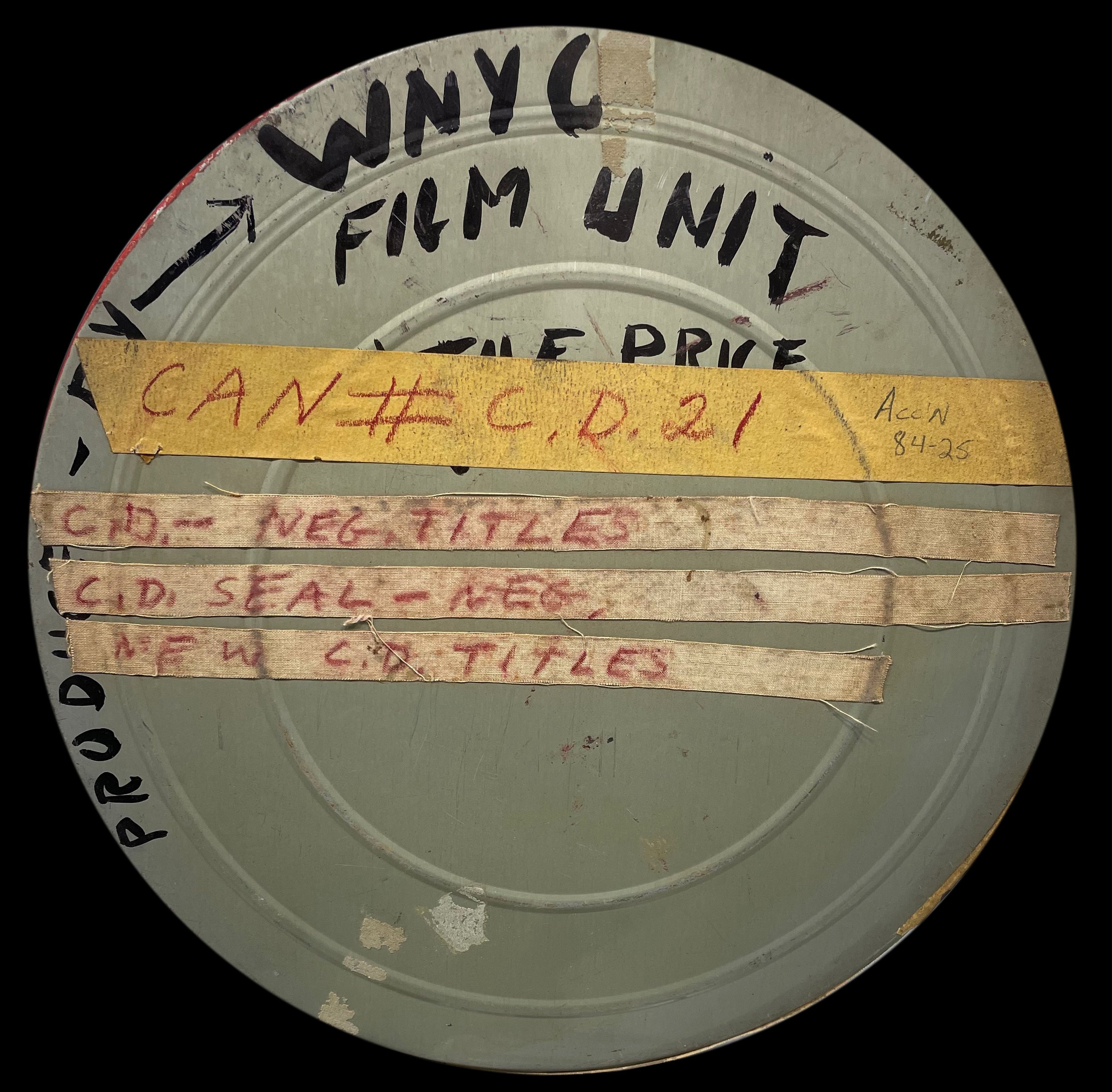
Original can from the WNYC Film Unit. WNYC collection, NYC Municipal Archives.

Meanwhile by the mid-to-late 1930s, the Federal Works Progress Administration (WPA) provided funding which underwrote half of the programming. It also supported construction of new studios for the station in the Municipal Building and a new transmitter in Greenpoint, Brooklyn. WPA artists even contributed murals and artwork for the studios. La Guardia changed his attitude and saw the station as an educational and cultural tool and began to use it as a way to talk directly to the people of the City. He also separated WNYC from the Department of Plant & Structures and created a new mayoral agency, the Municipal Broadcasting System, with Morris S. Novik as its director.

Title card from “Baby Knows Best,” a WNYC-TV production, ca. 1950s. WNYC collection, NYC Municipal Archives.

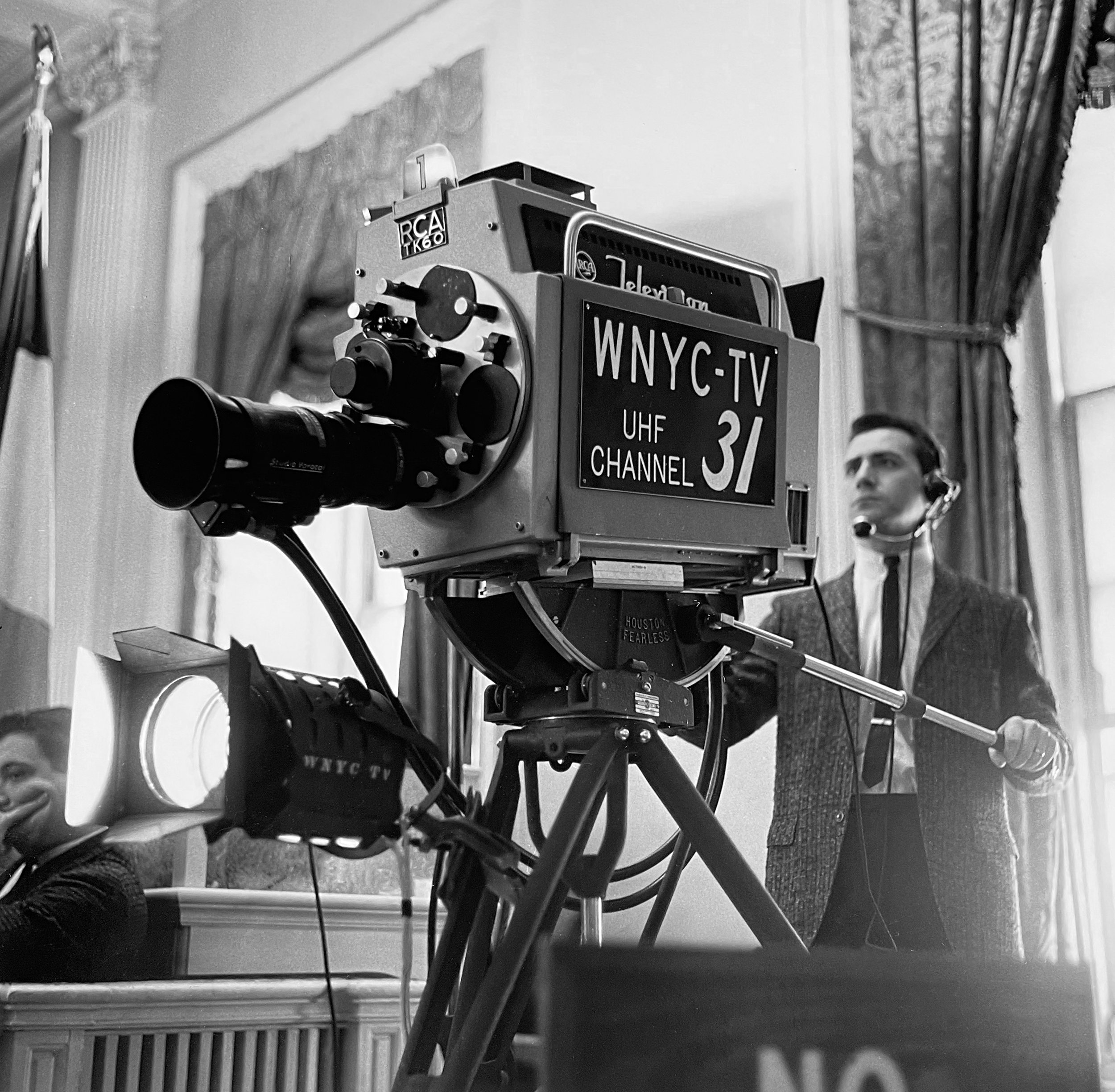
WNYC-TV cameraman in City Hall, ca. 1962. Photographer unknown. WNYC collection, NYC Municipal Archives.

Ralph McDaniels, creator of Video Music Box, on the cover of Wavelength, 1989. WNYC Archive Collections.

After World War II, Siegel, fresh from five years in the Navy, became the second director. Siegel continued to develop new educational programming for the station, and in 1949 he created the WNYC film unit to develop short educational films for the new medium of television. By 1962, WNYC-TV had its own television channel, the first municipal TV station in the nation. Facing massive budget cuts, Siegel turned in his resignation in 1971. The 1970s were not kind to WNYC, and in 1975 it held its first on-air membership drive to raise money. In 1979 the WNYC Foundation was formed with the idea of eventual independence from the City. In the 1980s, WNYC-TV broke new ground, with the first LGBT TV news series, Our Time, which premiered in 1983, and Video Music Box, which was launched by a young employee, Ralph McDaniels, in 1984. It was the first TV program to regularly air rap videos.

Staff on the roof of the Municipal Building for the 53rd Anniversary of WNYC, July 1977. Photograph by Sal de Rosa. WNYC Archive Collections.

Nelson Mandela receiving the key to the city from Mayor Dinkins, June 20, 1990. NYC Municipal Archives. https://www.wnyc.org/story/mandela-in-new-york/
FM Transmitter on top of World Trade Center, 1986. Photograph by Lisa Clifford. NYC Municipal Archives.

After a tumultuous review, Mayor Guiliani announced the sale of WNYC AM & FM licenses to the WNYC Foundation in 1995. WNYC-TV was to be sold at auction to commercial bidders. June 30, 1996, was the last broadcast of WNYC-TV, and on January 27, 1997, WNYC AM & FM were officially on their own. Of course, it took a little while to move out of the ‘attic.’ It was not until June 2008 that WNYC transferred the studios from the tower of the Municipal Building to the current Varick Street location.

More challenges awaited WNYC. In September 2001, WNYC lost its FM transmitter in the collapse of the north tower of the World Trade Center. The AM station continued to broadcast using a telephone land-line patch. In August 2003, the northeast blackout plunged the city into darkness, but the station stayed on the air with candlelight and emergency generators. In 2012, the WNYC-AM transmitter site in the new Jersey Meadowlands was damaged by Hurricane Sandy, taking it off the air. And in March 2020, WNYC had to set up home studios for its hosts as the COVID-19 pandemic shut down offices. Independence for WNYC also meant the launching of new magazine programing, podcasting, and a bevy of Peabody and other awards for programming including work by the producers of Radiolab, Studio 360, On the Media, Soundcheck and others.

Recovery efforts at Ground Zero, September 2001. Photographer unknown, Mayor Rudolph Giuliani collection. NYC Municipal Archives.

The Masterwork Bulletin, May-June 1971. WNYC Archive Collections.

Fitting 100 years of this history into a 20-foot-long shipping container presented a challenge. An easy solution would have been to just illustrate some part of the station’s history, but that did not seem to be fitting for this momentous birthday. The early years of WNYC were well photographed by Eugene de Salignac, agency photographer, but the Municipal Archives had few photos from the 1970s and 1980s. Luckily WNYC engineer Alfred Tropea had taken some beautiful color slides of the Greenpoint transmitter site and WNYC operations. And the WNYC program guides started to include more colorful covers with photographs of some hosts. Although Photoville centers on photography, we knew to tell the story we would need to use archival photographs, ephemera, and audio clips to celebrate WNYC’s history and importance to the City of New York. Even then, the story is too broad to tell fully. The exhibit had to be an immersive experience, with audio and visual components, so we settled on using four panels, each with a collage of images. A timeline underneath each panel marks highlights in the station’s history. An audio montage accompanies the visual panels:

WNYC 1924-2024, Audio montage 23 minutes
0:00 / 0:00

Brian Lehrer broadcasting from his home, March 2020. Wayne Schulmister/WNYC Engineering.

Not everything made the cut, and the reasons are rather random. The great blues musician Huddie ‘Leadbelly’ Ledbetter was a hugely important presence for WNYC in the 1940s, but the audio was hard to fit in. Pete Seeger and Woody Guthrie were also cut, but Bob Dylan’s first radio broadcast went in. Rebecca Rankin, despite her importance to the Municipal Archives, was cut from the exhibit, but stayed in the audio. For Photoville we wanted to include a panel discussion on modern photography with Edward Steichen, Margaret Bourke-White, Walker Evans, Irving Penn, and Ben Shahn from 1950 but it was hard to find a good short clip. Instead, we went with a rare interview with Diane Arbus, recorded shortly before her death in 1971. A 1961 Malcom X interview was left out and Martin Luther King, Jr. was included simply because the Malcolm X interview was not an official WNYC broadcast and the 1964 King event was an important City celebration. We had wanted to include something on gay rights in the wake of the 1969 Stonewall Riots, but we found a better clip of an ACT UP demonstration for more funding for the AIDS crisis, which happened to be recorded by a young reporter named Andy Lanset.

WNYC Transmitter building, Greenpoint, ca. 1980s. Photograph by Alfred Tropea, WNYC Archive Collections.


WNYC audio and WNYC-TV/Film collections are available from the NYC Municipal Archives and from the New York Public Radio Archive.

To learn more about WNYC’s history, follow Andy Lanset’s New York Public Radio History Notes Newsletter. Here are some highlights in addition to the links in this article.

  1. The night WNYC became real: www.wnyc.org/story/wnycs-first-official-broadcast

  2. WNYC and the Federal WPA:  www.wnyc.org/story/wnycs-wpa-murals

  3. The Plan and Promise of WNYC: www.wnyc.org/story/new-york-citys-silver-jubilee-plan-and-promise-wnyc

  4. Morris Novik and a Model of Public Radio: www.wnyc.org/story/218821-morris-s-novik-public-radio-pioneer

  5. WNYC’s ID – Hope for the World: www.wnyc.org/story/where-7-million-people-live-peace-and-enjoy-benefits-democracy

  6. Lead Belly on WNYC Throughout the 1940s: www.wnyc.org/story/king-twelve-string-guitar-wnyc-regular-through-1940s

  7. Christie Bonsack and Early WNYC: www.wnyc.org/story/christie-bohnsack-wnycs-first-director

  8. WNYC – The Station that Dodged Bullets: www.wnyc.org/story/wnyc-station-dodged-bullets

  9. WNYC’s Journey to Independence: www.wnyc.org/story/going-public-story-wnycs-journey-independence

  10. WNYC – Visions of a Flagship Station for a Cultural Network: www.wnyc.org/story/1937-vision-wnyc-flagship-station-non-commercial-cultural-network

100 Years of WNYC, Audio montage, list of clips

  1. Re-enactment of first 1924 WNYC broadcast, 1948

  2. Sweet Georgia Brown, Ben Bernie and His Hotel Roosevelt Orchestra, 1925

  3. Col. Lindbergh Tickertape Parade Reception, June 13, 1927

  4. Emergency Relief Committee Orchestra, 1931

  5. Station sign-off, December 1931

  6. Rebecca Rankin, Municipal Librarian, 1938

  7. News broadcast, 1938

  8. World’s Fair station ID, 1939

  9. Pearl Harbor attack broadcast, December 7, 1941

  10. Mayor La Guardia war-time Talk to the People, January 2, 1944

  11. Mayor LaGuardia reads the comics during newspaper strike, July 8, 1945

  12. Audio from City of Magic, WNYC-TV/Film, 1949

  13. AM and FM Station ID, January 11, 1950

  14. Bert the Turtle, Duck and Cover, ca. 1952

  15. Audio from This is the Municipal Broadcasting System, WNYC-TV/Film, 1953

  16. Eleanor Roosevelt DJs Elvis Presley’s song Ready Teddy, February 6, 1957

  17. Last run of the 3rd Avenue El, May 12, 1955

  18. Footloose in Greenwich Village, May 6, 1960

  19. Bob Dylan’s first radio appearance, October 29, 1961

  20. John Glenn, first American to orbit the earth, February 20, 1962

  21. President Lyndon B. Johnson, Gulf of Tonkin announcement, August 4, 1964

  22. Martin Luther King, Jr. welcome at City Hall, December 17, 1964

  23. Station ID, 1963

  24. Diane Arbus, interviewed for Viewpoints of Women by Richard Pyatt, September 2, 1971

  25. Shirley Chisholm announces run for presidency, January 25, 1972

  26. WNYC Golden Anniversary, Mayor Abraham D. Beame reading proclamation, July 8, 1974

  27. Mayor Ed Koch town hall in Jackson Heights, June 1, 1979

  28. Transit Strike, April 3, 1980

  29. “Voices of Disarmament” rally, June 14, 1982

  30. Vito Russo’s Our Time: Episode 1 - Lesbian & Gay History, February 16, 1983

  31. Philip Glass interviewed on New Sounds by John Schaefer, January 6, 1985

  32. ACT UP demonstration at City Hall, Andy Lanset reporting, March 28, 1989

  33. Ladysmith Black Mambazo, August 30, 1987

  34. Mayor David N. Dinkins and Nelson Mandela in New York, June 20, 1990

  35. Snap!, The Power, Video Music Box with Ralph McDaniels, WNYC-TV, September 14, 1990

  36. Audio from Heart of the City with John F. Kennedy, Jr., March 2, 1994

  37. WNYC Independence Celebration, January 27, 1997

  38. Kurt Vonnegut, Reporter for the Afterlife, 1998

  39. World Trade Center montage, September 11, 2001

  40. Brooke Gladstone, On the Media, December 20, 2002

  41. Blackout announcement, August 14, 2003

  42. David Garland, NYPR takeover of WQXR, October 8, 2009

  43. RadioLab intro, February 20, 2010

  44. John Schaefer, Soundcheck live from The Greene Space, December 15, 2011

  45. Hurricane Sandy aircheck, October 29, 2012

  46. Brian Lehrer Show, first broadcast from his apartment due to COVID-19, March 16, 2020

  47. Protests, September 4, 2020

  48. All of It, Allison Stewart, October 21, 2021

  49. New Yorker Radio Hour, May 11, 2024

  50. Notes From America with Kai Wright, May 19, 2024

  51. Morning Edition, Michael Hill with Andy Lanset on the Anniversary of WNYC, July 8, 2023

Radio Row and the Fight for Lower Manhattan

It has been said that nobody loved the Twin Towers until they were gone, and that is certainly true of the residents and business owners of the Manhattan neighborhood known as Radio Row. One of many such “Radio Rows” in cities throughout America, New York City’s was the largest and one of the oldest. It was roughly bounded by Dey Street to the north, Liberty to the south, between West and Church Streets. The heart of it was Cortlandt and Greenwich Streets, but another concentration of shops lined Dey Street (also known as Telegram Square for the Western Union Building at the corner of Broadway and Dey). At its peak over 400 merchants sold radios, televisions, and associated parts in this area.

DaVega City Radio, 63 Cortlandt Street, ca. 1939. Tax Photograph Collection, NYC Municipal Archives.

North-Star Radio, 78-80 Cortlandt Street, ca. 1939. Tax Photograph Collection, NYC Municipal Archives.

From the earliest days of radio in the 1920s, dealers in radios and radio parts set up shop in the area. As car radios became more common, some shops specialized in conversion kits for autos. Other shops just sold vacuum tubes, which frequently burned out and were often non-standard parts hard to find.

By the time the New York City Department of Finance Tax Photo project got underway in the late 1930s, the area was bustling with vendors and buyers. A famous 1936 WPA Federal Writers’ Project photograph shows a crowd of men standing along Cortlandt Street in front of DaVega City Radio listening to a World Series game between the then New York Giants and the Yankees. A second photo reveals why they are all looking across the street: two men hanging out the window of Atlas Radio updating a scoreboard. The neighborhood was not just about radios, as revealed in the Tax Photos: bicycle shops, bars, coffee shops, diners, hotels, pet shops and automotive stores also were packed into the old brick buildings. A few newer buildings housed insurance companies. In the 1950s, televisions became popular, and Radio Row vendors started to sell them, and their components, as well.

Men watching World Series announcement board, Cortlandt Street (Radio Row), 1936. WPA Federal Writers' Project collection, NYC Municipal Archives.

The World Series announcement board above Atlas Radio, which the men on Cortlandt Street were watching, 1936. WPA Federal Writers' Project collection, NYC Municipal Archives.

Bell Radio, 60 Cortlandt Street, ca. 1939. Tax Photograph Collection, NYC Municipal Archives.

Weston Radio, 64 Cortlandt Street, also Times and Publix Radio, ca. 1939. Tax Photograph Collection, NYC Municipal Archives.

Vim Radio, 70 Cortlandt Street, ca. 1939. Tax Photograph Collection, NYC Municipal Archives.

Arrow Radio, 82 Cortlandt Street, ca. 1939. Tax Photograph Collection, NYC Municipal Archives.

Detail of a 1934 GW Bromley atlas of Manhattan showing the area where Radio Row existed. Everything from Liberty to Vesey Street, from Church to the river was demolished for the World Trade Center in 1966 and 1967. NYC Municipal Archives.

It was a successful business district, even if a bit unsightly, but by the 1960s Lower Manhattan was slated for a dramatic change. The waterfront businesses essential to a port city were no longer needed, as a new era of trucking and the introduction of the cargo container took hold. In addition, airplane travel reduced the number of passenger ships coming into the Manhattan docks. David Rockefeller, Chairman of Chase Manhattan Bank (and brother of Governor Nelson Rockefeller), envisioned a World Trade Center that could revitalize Lower Manhattan. He had already used political pressure and eminent domain to build One Chase Plaza in 1956 on the site of the old sail-making lofts of the Coenties Slip area near the Financial District. He thought the area just north, South Street Seaport, would be the perfect site for his World Trade Center. He created the Downtown-Lower Manhattan Association (DLMA) to remake Lower Manhattan. To bring in more financing, he approached the Port Authority of New York and New Jersey, an interstate compact created in 1921. However, New Jersey Governor Robert Meyner saw nothing in the project for New Jersey. Eventually, New York Governor Nelson Rockefeller struck a deal that would move the project to the west side if the Port Authority would take over the bankrupt Hudson & Manhattan Railroad and build the new World Trade Center on top of its southern terminal, creating the PATH train system. The plan also called for the Port Authority to destroy the freight piers along West Street and build container ports at the Port of Newark-Elizabeth, New Jersey.

Letter from the Downtown-Lower Manhattan Association to Mayor Lindsey, February 1966. Mayor Lindsey Collection, NYC Municipal Archives.

Letter from Mayor Lindsey to David Rockefeller, August 1966. Mayor Lindsey Collection, NYC Municipal Archives.

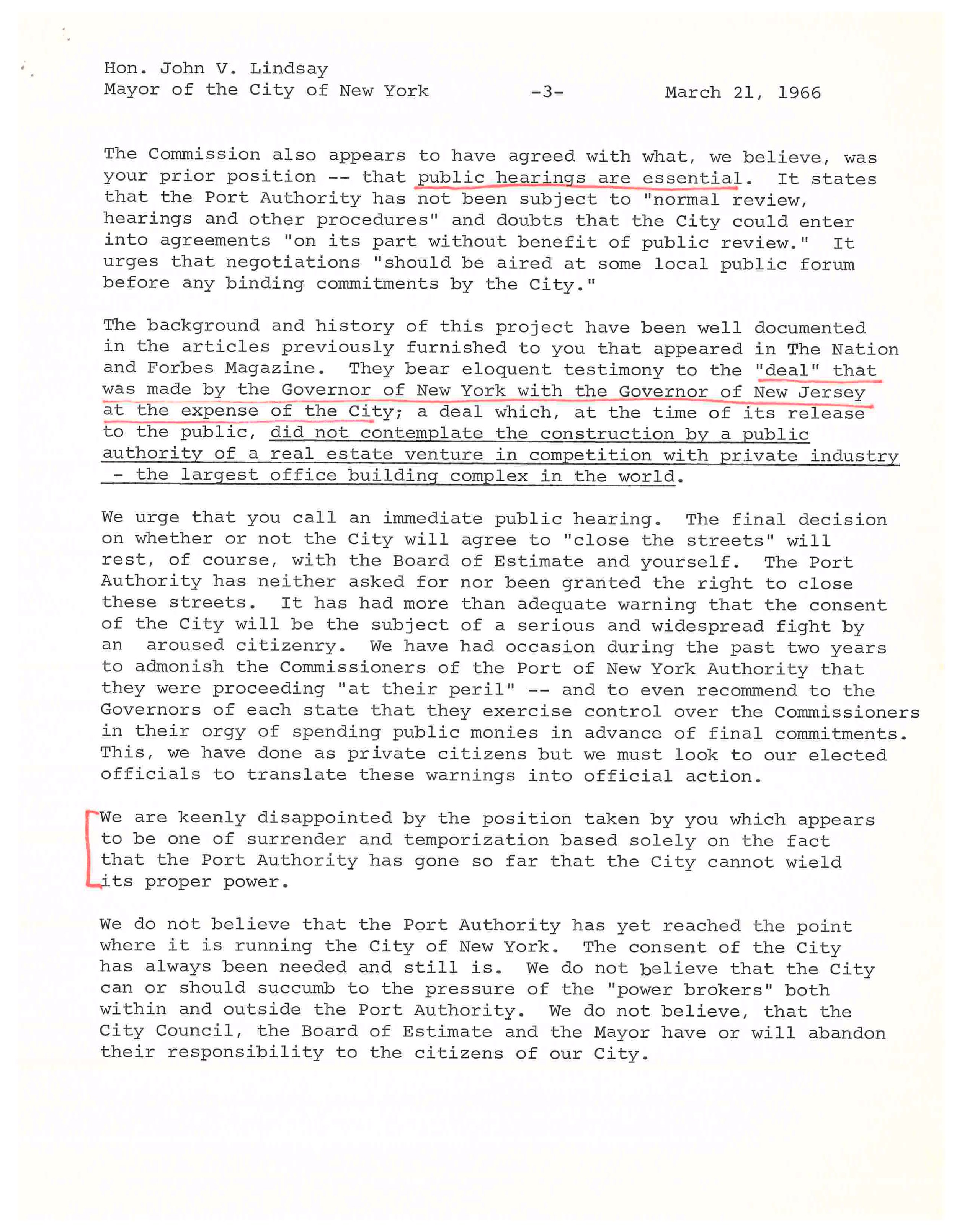
Emergency Committee to Oppose the World Trade Center letter, November 1966. Mayor Lindsey Collection, NYC Municipal Archives. The Committee was made up of prominent journalists, historians, and architectural critics, including Jane Jacobs, fresh from her fight against Robert Moses’ Lower Manhattan Expressway.

Telegram from Thomas Maguire, Vice President International Union of Operating Engineers to Mayor Lindsey, urging him to press forward with the Trade Center, March 1967. Mayor Lindsey Collection, NYC Municipal Archives.

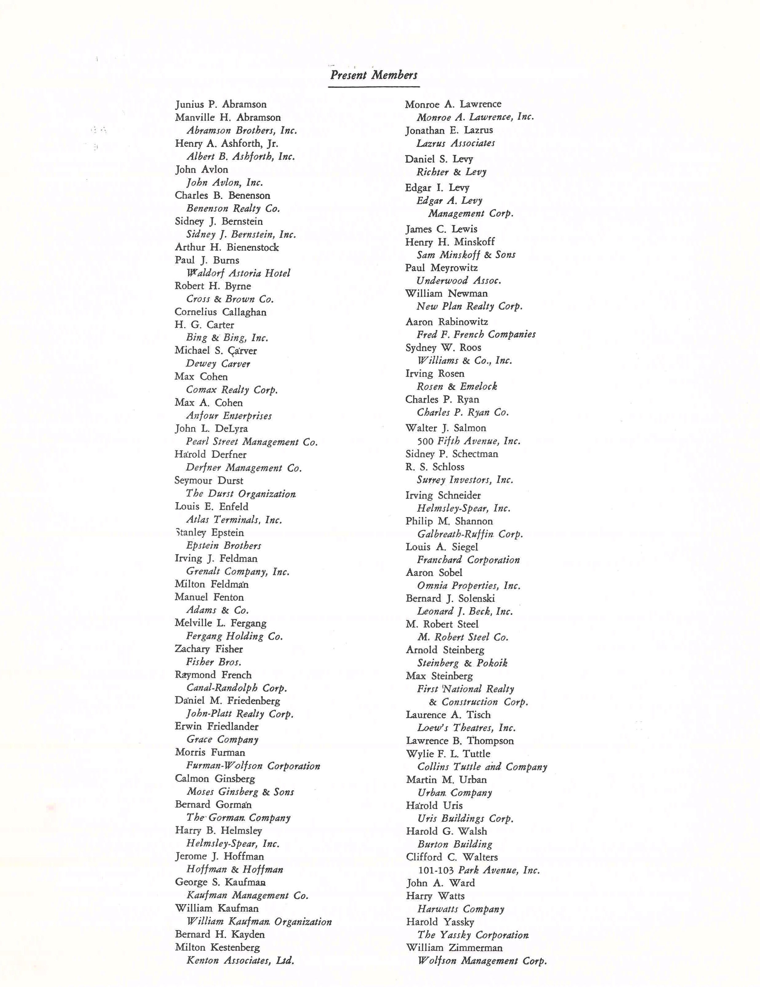
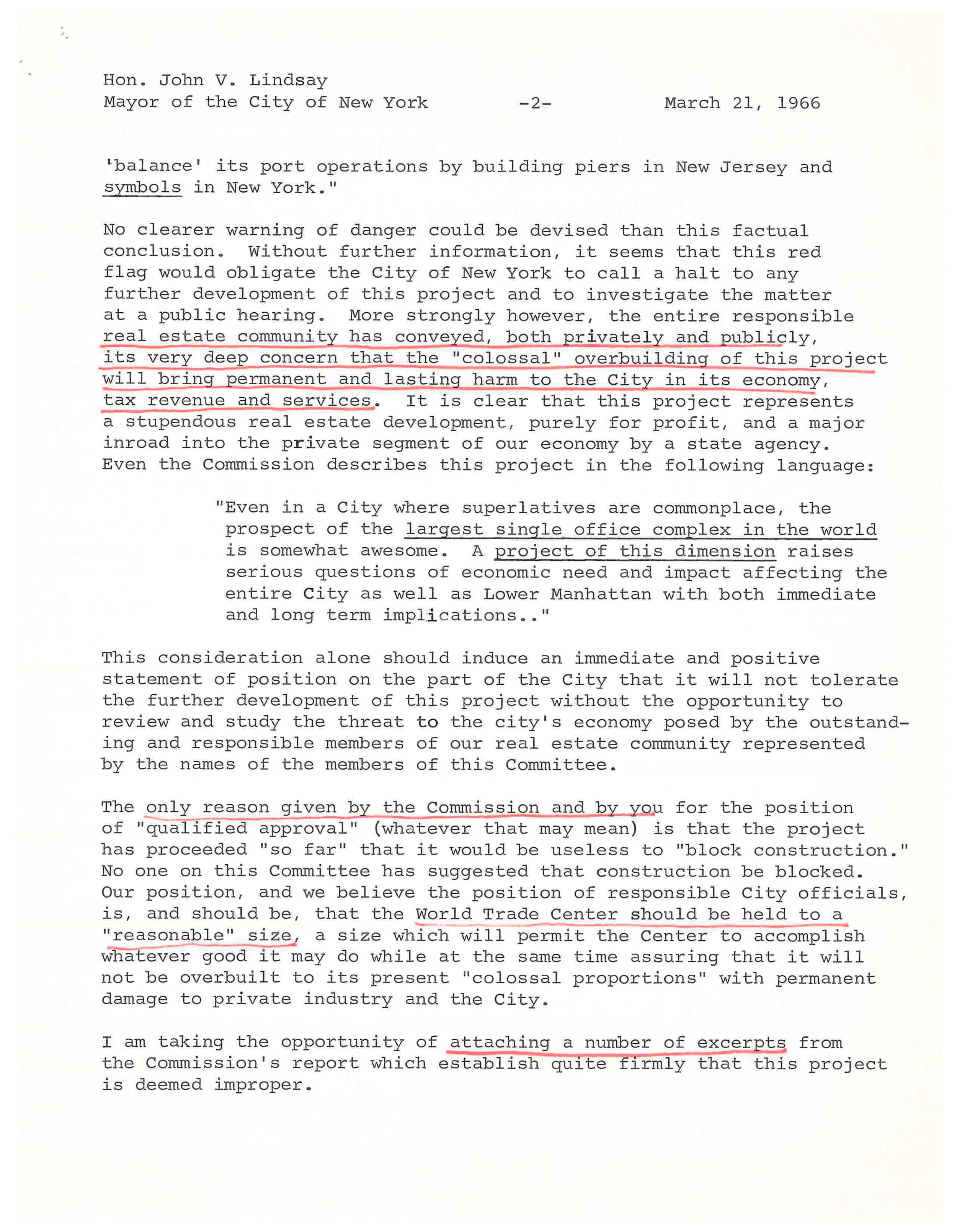
The radio-shop owners had initially been fans of the proposed east-side trade center, which they thought would bring in new business. However, when they saw plans for the west side and realized the proposed site would completely wipe out their business district, they formed the Downtown West Businessmen’s Association and started to advocate against the project. Headquartered at Oscar’s [Nadel] Radio Shop at 63 Cortlandt Street (formerly DaVega City Radio) they fought the plan through protests, legal challenges, and street theater. They were joined by other groups, including the Committee for A Reasonable World Trade Center (made up of prominent real-estate families), and the Emergency Committee to Oppose the World Trade Center, a more literary and artsy group, which had amongst its members Jane Jacobs. Mayor Lindsey’s subject files contain a thick folder from 1966-1967 with correspondence on the World Trade Center from and to these groups. Also represented are commerce and labor groups that strongly advocated for the project to fight the economic slump in the building trades.

Letter from the Downtown West Businessman’s Association, February 1966. Mayor Lindsey Collection, NYC Municipal Archives.

Letter from the Downtown West Businessman’s Association, February 1966. Mayor Lindsey Collection, NYC Municipal Archives.

Letter from the Committee for a Reasonable World Trade Center, March 1966. Mayor Lindsey Collection, NYC Municipal Archives. This committee represented prominent real-estate interests, who feared the new trade center would devalue commercial real estate in the City.

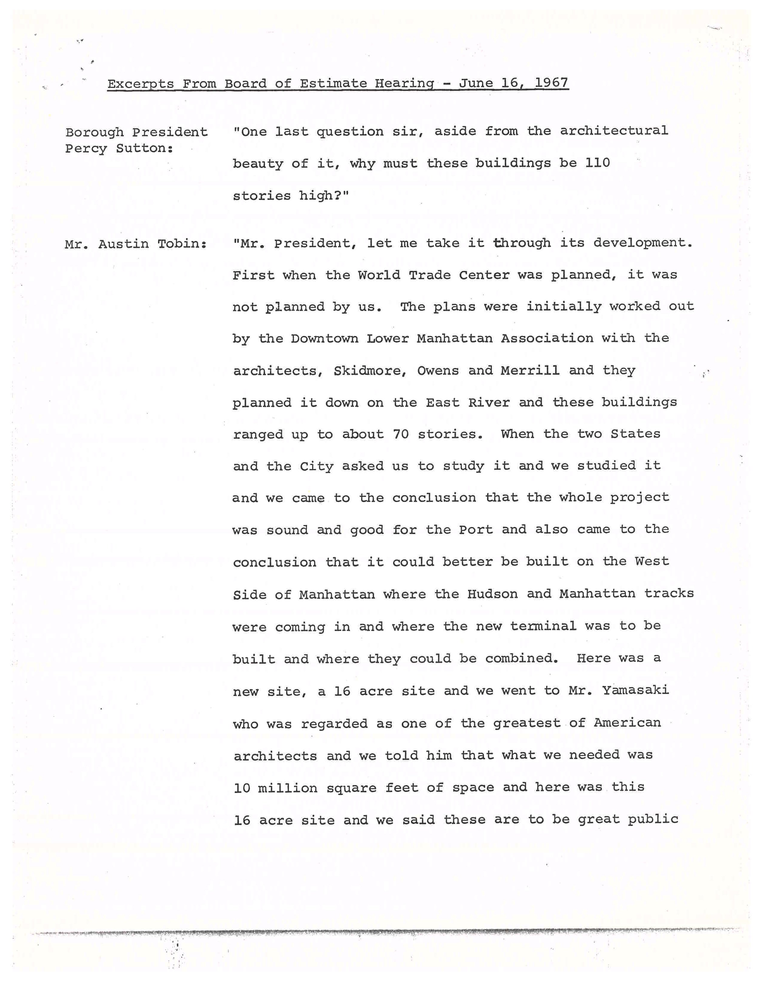
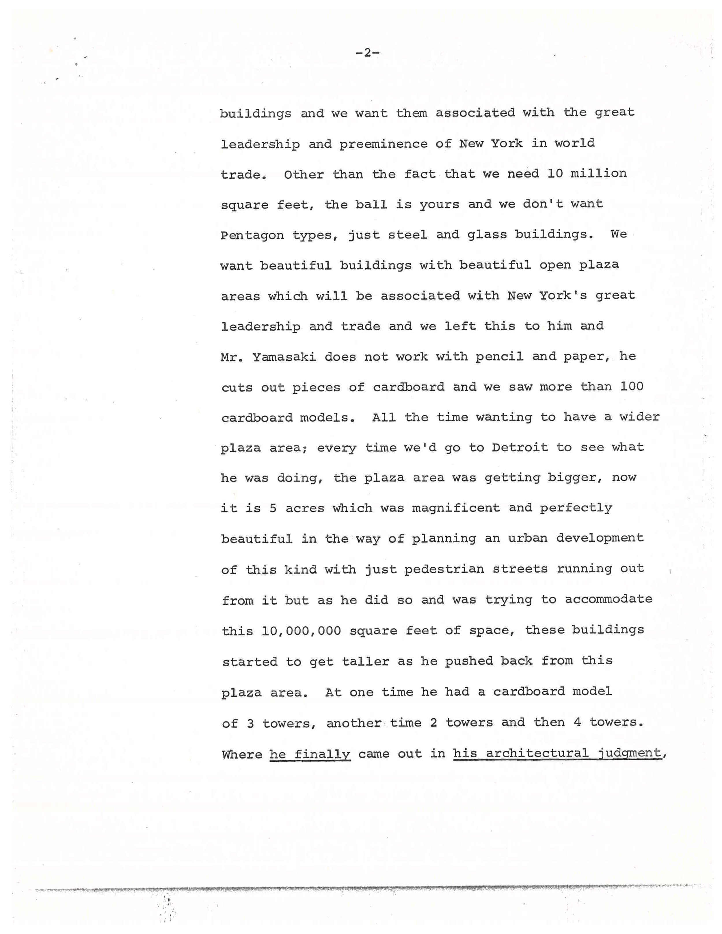
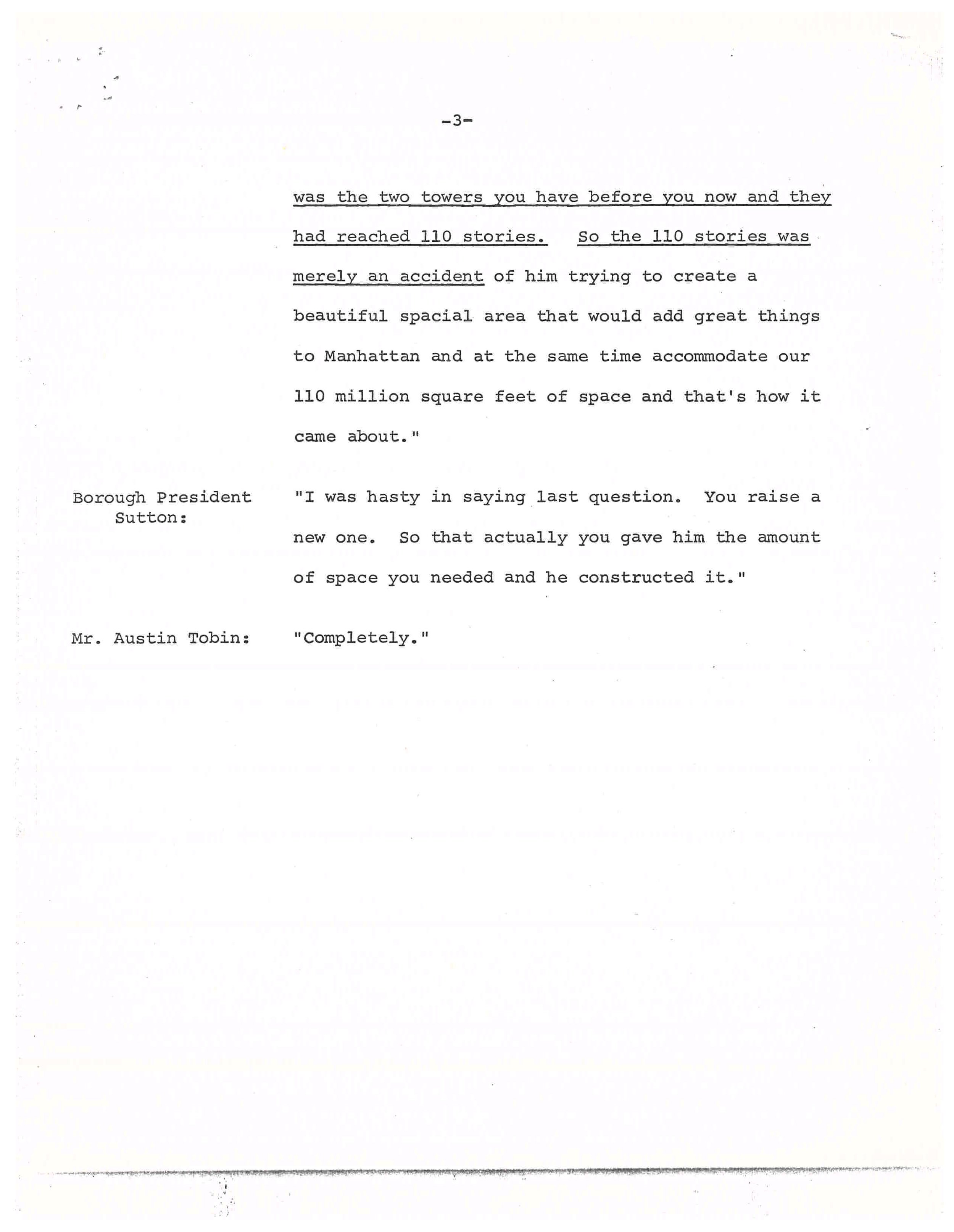
Excerpt from Manhattan Borough President Percy Sutton questioning Port Authority director Austin Tobin, Board of Estimate Hearing, June 16, 1967. Mayor Lindsey Collection, NYC Municipal Archives.

Harper’s Magazine, “New York’s Trade Center: World’s Tallest Fiasco,” advance proof of May 1966 edition. Mayor Lindsey Collection, NYC Municipal Archives.

Destruction of Radio Row, looking south along Greenwich Street from number 189, ca. April 1966. Jean M. Brown photographer, NYC Municipal Archives Collection.

The Port Authority offered Radio Row merchants $3,000 to relocate, and some did move—dispersing to Canal Street, Union Square and west of Times Square—but many refused the payments and simply went out of business. Eventually the project was pushed through, and by May of 1966 the architecture critic for Harper’s Magazine, Wolf von Eckardt, lamented “It’s ready to go up right now. How did the plans get this far?” He said the proposed “instrument of urbicide… not only the tallest, but unquestionably one of the ugliest buildings in the world,” would displace “thirteen historic, living and breathing square blocks of the city.”[1]

One resident of those thirteen blocks was Jean M. Brown, a young woman living at 189 Greenwich Street and working as a typist. She had a front row seat to the destruction of Radio Row and, using an amateur camera, she documented it from her 3rd floor window. Brown also took a photo of her own building before she too was evicted by the Port Authority in November of 1966, while seven-months pregnant. Brown just passed away in August 2023, but her son William recently recalled that she sent eleven photos to the Municipal Archives in 2005 because she wanted someone to remember what had once been a thriving neighborhood. In her donation letter she wrote, “I hope that this will be of help to future individuals who are interested in what that part of Manhattan looked like before the Trade Center was erected.”

Jean M. Brown lived on the 3rd floor of 189 Greenwich Street, above Adson Radio, until she was evicted in November 1966. Jean M. Brown photographer, NYC Municipal Archives Collection.

Super Radio Outlet, 65-67 Dey Street, ca. 1939. This address would later betaken over by Leotone Radio (see photo below). Tax Photograph Collection, NYC Municipal Archives.

61 Dey Street (far left) to 71 Dey Street with Washington Street and Pier 13 beyond, looking west from 189 Greenwich Street, June 1964. Jean M. Brown photographer, NYC Municipal Archives Collection.

Dismantling of Pier 13, Dey Street, looking west from 189 Greenwich Street, ca. April 1966. Jean M. Brown photographer, NYC Municipal Archives Collection.

Workers demolishing 65-67 Dey Street, looking west from 189 Greenwich Street, late summer or fall of 1966. Jean M. Brown photographer, NYC Municipal Archives Collection.

Destruction of Radio Row, Dey Street, looking west from 189 Greenwich Street, ca. November 1966. The West Side Elevated Highway is clearly visible in the background. A section of it collapsed in December 1973 and it was eventually removed in 1989. Jean M. Brown photographer, NYC Municipal Archives Collection.


[1] “New York’s Trade Center World’s Tallest Fiasco,” Harper’s Magazine, May 1966.

Further reading:

http://tribecatrib.com/content/world-trade-center-long-lost-world-radio-row

http://www.antiqueradio.com/Radio_Row_09-98.html

https://www.qcwa.org/radio-row.htm

A Spanish-American War Mystery

For Veterans’ Day, we are highlighting an interesting group of glass lantern slides from the Queens Borough President collection. The slides are mostly scenes of soldiers working, relaxing, and playing at an army camp in a rural setting. In our online gallery they are simply listed as “Twenty-four views of mobilization camp or state militia camp, probably in Virginia, before or during Spanish-American War, ca. 1896-1898.” Why these images are in a collection of photographs created by the Queens Borough President Topographic Bureau was a complete mystery.

Soldiers in camp, 1898. James T. Chapman, photographer, Queens Borough President Collection, NYC Municipal Archives.

Soldiers in camp, 1898. James T. Chapman, photographer, Queens Borough President Collection, NYC Municipal Archives.

Soldiers in camp, 1898. James T. Chapman, photographer, Queens Borough President Collection, NYC Municipal Archives.

Soldiers in camp, 1898. James T. Chapman, photographer, Queens Borough President Collection, NYC Municipal Archives.

Initially, we surmised the images might be from Camp Wikoff, a quarantine camp established in Montauk, Long Island for troops returning from Cuba. As noted in a previous blog, disease, including typhoid, and yellow fever were endemic in Cuba, claiming the lives of more soldiers than died in battle. Concerned about spreading an epidemic in the United States, the army established Camp Wikoff to quarantine troops for several months before mustering out. The photographs of Camp Wikoff available online show a similar arrangement of tents and temporary wooden structures, but the Montauk site was barren, while our slides have a number of large trees in the background. In addition, two slides show troops in a downtown area with brick buildings. In one of these, soldiers pause in front of a pawn shop, behind them soldiers sit on the ledge of a building advertising “Fitzgerald-Photographer” and “S.N. Campbell-Sup’t-The Life Insurance Co. of Virginia.”

Soldiers in front of a pawn shop, possibly in Falls Church, Va., 1898. James T. Chapman, photographer, Queens Borough President Collection, NYC Municipal Archives.

This is where the Virginia reference originated, but what were these images doing in the Queens collection? Looking at the original slides for more information yielded another clue. Glass lantern slides were made by projecting an original glass negative at another piece of glass coated with photographic emulsion. Once developed, the result would be a positive image. To protect the image from dust and fingerprints during projection, the emulsion was sandwiched between another piece of glass, often with a paper mask curved at the top edges. Sometimes these are generic, but in this case, we were lucky as the paper mask was decorative and personalized with the name “Jas. T. Chapman, Flushing, L.I.”

Soldiers blanket tossing at Camp Meade, Pa. 1898. James T. Chapman, photographer, Queens Borough President Collection, NYC Municipal Archives.

Here was a Queens connection. But what was James T. Chapman of Flushing doing in Virginia and how did his photographs end up in this collection? Searches on Ancestry and in Queens City directories yielded a James Treadwell Chapman, listed variously as a clerk, or secretary, who died in 1901 of kidney disease. The personalized slide frames suggested a professional photographer or serious amateur, but no photographer by the name of Chapman was listed in the directories. However, as we discussed in a previous blog, camera clubs were very active in New York in the 1880 and ‘90s, and lantern slides were a common way for members to share their work at meetings. Chapman was not listed as a member of the New York Camera Club, but numerous other clubs existed in New York, including the Society of Amateur Photographers. Both clubs had regular “lantern slide test” nights when amateurs could project slides for review, and clubs exchanged slides with clubs in other cities, including those in Europe and Australia. Chapman was probably a sufficiently serious amateur that he had personalized frames made to ensure his slides would be returned to him after such exchanges.

Soldiers from Flushing at Camp Meade, 1898. James T. Chapman, photographer, Queens Borough President Collection, NYC Municipal Archives.

Another search in the Queens Borough President collection for “Chapman” revealed an additional image, from a small group of prints labeled “Chapman collection.” BPQ_03133-f shows a group of soldiers around an L sign. It is captioned: “Spanish-American War, Soldiers from Flushing at Camp Meade, 1898.”

Camp Meade was established in August 1898, near Middletown, Pennsylvania, as a replacement for Camp Alger in northern Virginia, which was overrun with a typhoid fever epidemic. Camp Alger and Camp Meade were very much in the New York news in 1898, with the New York Times proclaiming on August 20, 1898: “Camp Meade Filling up; Thirty Thousand Men Are Expected in Ten Days and More Ground is Needed. Third New York’s Sick List Twelve Per Cent. of Its Men Confined to Their Quarters…” The article detailed recent deaths and the efforts to muster out troops scheduled to leave service. Adjunct General Tilinghast gave a press conference at the Waldorf-Astoria after returning to New York from a meeting with the Secretary of War, where he requested that “troops who had seen actual service, and those who have been in camp in localities where fever is prevalent, and those who for commercial reasons are most needed at home should be mustered out first.” He also mentioned that the 201st, the 202nd, and the 203rd NY regiments wished to remain in service. “These regiments are composed of very loyal men, who desire to remain soldiers as long as possible.”

African-American troops, 1898. The War Department encouraged recruitment of Black regiments as they believed they would be immune to tropical diseases such as yellow fever. This may be the 9th Ohio Battalion, a segregated battalion of the Ohio National Guard led by Charles Young, which was stationed at Camp Alger and Camp Meade. James T. Chapman, photographer, Queens Borough President Collection, NYC Municipal Archives.

Soldiers playing basketball at Camp Meade, 1898. Basketball, which was developed in 1891, was already popular by 1898, but the backboard was not introduced until 1906. James T. Chapman, photographer, Queens Borough President Collection, NYC Municipal Archives.

Families visiting soldiers at Camp Meade, 1898. James T. Chapman, photographer, Queens Borough President Collection, NYC Municipal Archives.

The Times followed up on August 26th with an article “Review by the President, Troops at Camp Meade will March Past Him Tomorrow.” And on September 13th, they wrote that the “Third New York Quits Camp Meade.” However, on October 5th they published a new article, “Sick New York Troops at Camp Meade.” They reported that “Major Shakespeare of Philadelphia is making a study of the outbreak of typhoid among the New York regiments at Camp Meade…. The Two Hundred and Third New York has 400 cases of typhoid fever and is still isolated in the Conewago Hills, eight miles from the other troops.” The Surgeon General’s commission, which also included Major Walter Reed, eventually produced a “Report on the Origin and Spread of Typhoid Fever in U.S. Military Camps During the Spanish War of 1898.” At 2600 pages long, it was a landmark in modern medicine and led to reforms throughout the Army and national medical systems. The 203rd would remain in additional quarantine until November 12, 1898, when they left for a winter encampment in South Carolina. By November 18th, the Times reported “Camp Meade Now Wholly Deserted.” On December 10, 1898, the Spanish-American War ended with the Treaty of Paris and the 203rd never saw foreign service.

Soldiers at Camp Meade, 1898. James T. Chapman, photographer, Queens Borough President Collection, NYC Municipal Archives. On the back of the print, James W. Chapman is listed as 3rd from left, but it is unclear if that is standing or the leftmost seated figure.

One more thing, on October 29th, while the 203rd was still quarantined at Conewago, a young corporeal from Company F of Flushing, New York was promoted to sergeant. His name was James W. Chapman, James T. Chapman’s 21-year-old son. It seems that Chapman was able to visit his son at least once and take these photographs of the camp, and it is likely that the views of the downtown area are from Falls Church, Virginia when they were at Camp Alger earlier in the year. How these images came to be in the Queens Borough President’s collection is still a mystery, but there is another clue. Image 3133-k is entitled “Flushing Village Trustees – 1887” and with the print there is a typed slip of paper identifying the trustees, including one James Chapman.

Flushing Village Trustees Outing near the Flushing Water Works Station, 1887. James Chapman is listed as #7 in the back row, but that position is open to interpretation. Photographer unknown, Queens Borough President Collection, NYC Municipal Archives.

George Washington Centennial, Civic and Industrial Parade, April 29-May 1, 1889. James T. Chapman, photographer, Queens Borough President Collection, NYC Municipal Archives.

There are no other references to the “Chapman Collection” amongst the negatives, although at least one glass negative in the collection is a view duplicated in one of his lantern slides of the 1889 Washington Centennial parade. (An April 1889 NY Times article revealed that members of the Society of Amateur Photographers were stocking up on plates to photograph the centennial). In the 35 lantern slides we can positively identify as Chapman’s there are a few other lovely images, some of which have appeared before in For the Record. A couple of his images are hand tinted. Many of his images have a military connection, including a series of plates showing the parade for Admiral Dewey after his 1899 return from the Philippines.

From the events depicted, we can tell that Chapman was active as a photographer from at least 1889 to 1899. As a relatively prominent figure in Flushing, he may have had dealings with the Borough President’s office, which formed in 1898 with the consolidation of the boroughs. Perhaps after Chapman’s untimely death at age 48 in 1901 they were donated by his family. He had nine children, including his eldest son James, who not only survived the typhoid pandemics at Camp Alger and Camp Meade, he lived another 80 years, dying in the 1970s.

Calvary troops in formation near the Washington Bridge, probably preparing for the Admiral Dewey Parade, September 30, 1899. James T. Chapman, photographer, Queens Borough President Collection, NYC Municipal Archives.

Admiral Dewey Parade, September 30, 1899. Admiral Dewey in cockaded tricorn salutes crowd. Mayor Van Wyck in top hat seated by him. James T. Chapman, photographer, Queens Borough President Collection, NYC Municipal Archives.

West Point cadets, 7th Regiment marching in Admiral Dewey Parade, September 30, 1899. James T. Chapman, photographer, Queens Borough President Collection, NYC Municipal Archives.

Hand-tinted lantern slide of a bicyclist in the woods, ca. 1890s. James T. Chapman, photographer, Queens Borough President Collection, NYC Municipal Archives. The bicycle fad and amateur photography developed simultaneously in the late 1800s.

A family at a Queens beach cottage, ca. 1898. James T. Chapman, photographer, Queens Borough President Collection, NYC Municipal Archives.

Anniversary of Wall Street

The 13th of March marks another important anniversary in the history of New Amsterdam. For on March 13, 1653, less than two months after New Amsterdam formed its first municipal government, it faced an existential threat. The 1st Anglo-Dutch war had broken out in late 1652, and word had reached Governor General Petrus Stuyvesant and the council of Burgomasters and Schepens that English troops were amassing in New England for a possible overland invasion from the north. From the records of New Amsterdam:

“Upon reading the letters from the Lords Directors [of the Dutch West India Company in Amsterdam] and the last received current news from New England concerning the preparations there for either defense or attack, which is unknown to us, it is generally resolved:

First. The burghers of this City shall stand guard in full squads overnight…

Second. It is considered highly necessary, that Fort Amsterdam be repaired and strengthened.

Third. Considering said Fort Amsterdam cannot hold all the inhabitants nor defend all the houses and dwellings in the City, it is deemed necessary to surround the greater part of the City with a high stockade and a small breastwork….”[1]

From the 13th to the 19th of March 1653, they discussed the plans for defense and how to bid out the work. And on the 17th, someone, possibly even Stuyvesant himself, drew a little sketch in the margins of the court record of a cross-section of the defenses, consisting of a ditch, embankment and palisade wall. The wall built by the spring of 1653 to defend against the English would eventually give its name to Wall Street (although the Dutch called it Het Cingel, the Belt). All of this I have covered thoroughly in past blogs, but a few new questions have arisen concerning the history of the wall.

Court minutes from March 17th, 1653. The sketch of the wall is in the margin in the middle. Records of New Amsterdam, NYC Municipal Archives.

Diagram of the proposed wall from the Court Minutes of New Amsterdam, March 17, 1653. Records of New Amsterdam, NYC Municipal Archives.

The exterior has an embankment and a ditch, and the line projecting from the top of the wall may be a fraise, small sharp sticks to impede scaling the wall. The Dutch reads: “9 feet above ground, 3 feet in ground.” One dot = one foot. In the end a palisade proved too costly, and they used slats across posts set 15 feet apart.

A recent Bowery Boys podcast about the wall kindly directed listeners to my earlier blogs. However, one part of the story intrigued/stumped me. They reference an earlier wall built in 1644 near the end of Governor Kieft’s war with the native tribes. Was it possible that the wall really was built to defend against attacks by the natives and not the English? This blog explores that possibility and raises new avenues for exploration. The language quoted in these records obviously reflects the viewpoints of the Dutch colonial government. The Municipal Archives plans to add new content to New Amsterdam Stories by 2024 describing colonization from the perspectives of the original Munsee Lenape inhabitants and enslaved peoples to coincide with the 400th anniversary of Dutch settlement on Manhattan. These long over-due stories were originally planned when the website was launched, but the relocation of our offsite collections and COVID disrupted these plans.

The source for the 1644 wall claim is a Curbed New York article that references an article in Harper’s magazine “The Story of a Street,” from 1908, by Frederick Trevor Hill. In it, Hill wrote that on March 31, 1644, Kieft ordered a barrier to keep in stray cattle and defend against Native Americans. Hill was a lawyer and historian, and his enjoyable, but rather fanciful, article does get some things right, like this footnote:

“About this time (1655-6) the residents of Pearl Street, inconvenienced by the high tides, caused a sea wall to be erected, and the space between this barrier and their houses to be filled in, making a roadway known as De Waal, or Lang de Waal. Incautious investigators have confused this with Wall Street, and their error has resulted in some astonishing ‘history.’”

Very true. Since he was correct about this, his 1644 claim bears investigating. For the original source we need to go to records in the New York State Archives:

“31st of March [1644]

Whereas, the Indians, our enemies, daily commit much damage, both to men and cattle, and it is to be apprehended that all of the remaining cattle when it is driven out will be destroyed by them, and many Christians who daily might go out to look up the cattle will lose their lives; therefore, the director and council have resolved to construct a fence, palisade, or enclosure, beginning from the great bouwery to Emmanuel’s plantation. Everyone who owns cattle and shall desire to have them pastured within this enclosure is notified to repair there with tools next Monday morning, being the 4th of April, at 7 o’clock, in order to assist in constructing the said fence and in default thereof he shall be deprived of pasturing his cattle within the said enclosure.”[2]

Already the claim starts to fall apart, as what is described is a cattle pen not a defensive wall. The main concern seems to be that cattle would wander up-island when put out to pasture, which was dangerous for the cattle and for colonists who were in the woods looking for them. Earlier records scold colonists for letting their cattle trample the maize fields, which caused conflict with the Lenape and hurt the supply of grain for the colonists. Incidentally, the next two passages in the state records are notices of the peace treaties signaling the end of the war.

So not a wall, but where was this cattle fence? Hill thought it ran from “William Street… to what is now Broadway, and possibly from shore to shore, marked the farthest limits of New Amsterdam, as it then existed, and practically determined the location of Wall Street.”[3] Hill then went on to colorfully describe Stuyvesant in 1653 “stumping along the line of Kieft’s old cattle guard, seeking an advantageous location for the Palisade…” and placing it “some forty or fifty feet south of the old barrier and practically parallel to it….”[4]

Map of the Original Grants of village lots from the Dutch West India Company to the inhabitants of New-Amsterdam, (now New-York), lying below the present line of Wall Street, grants commencing A.D. 1642. Map created by Henry Dunreath Tyler, ca. 1897. Courtesy New York Public Library. Hill may have seen this map produced 10 years before his article, for he thought the cattle enclosure started east of the Sheep Pasture, and extended to Broadway, but there are no patentees on this map named Emmanuel.

Was this really the correct location? According to the original 1644 records, the enclosure was to run from “the great bouwery to Emmanuel’s Plantation.” Bouwerie is Dutch for farm, and the street now named Bowery was indeed the road that led to tracts of Dutch farmland. The “Great Bouwery” most likely referred to the large tract of Company farmland that ran from Bowery Street to the East River, later to become Stuyvesant’s farm, but all these large farms were north of present-day Worth Street. And where was Emmanuel’s Plantation? Historian I.N. Stokes identified Emmanuel as Emmanuel Pietersen. No map shows the exact location of his farm, but Stokes notes that Emmanuel was previously known as Manuel Minuit, perhaps because he had been enslaved by Pieter Minuit, founder of New Amsterdam.[5]

The large Dutch farms were located east of Bowery [the dashed line from point 4 to 16] in what would now be the East Village and Lower East Side. The “Great Bouwery” is number 1 on the map just above #16 (the Brewery). The key says “No1 Comp Bouwery met Een Traffelleyck Huys” [Company’s Bouwery with an excellent house]. Eventually this would become Stuyvesant’s farm. The farms given to freed Blacks in 1644 likely stretched from numbers 9 to 10 on this map. Jan Pietersen’s Plantation (#9) was just above Spring Street near Minetta Creek. It is possible Emmanuel had worked this land and was given the northern portion. Manatus Map [detail], 1639. Courtesy Library of Congress.

Key to the Manatus Map, 1639. Courtesy Library of Congress.

Less than two months before the fence ordinance, on February 25th, 1644, the Dutch West India Company resolved the petition of ten enslaved men who were demanding their freedom. They were granted conditional freedom for themselves and their wives, but not for their children who remained enslaved to the Company. The Company gave them farmland north of the town that had been abandoned by white settlers during Kieft’s war. The area became known as the Land of the Blacks, and eventually remnants of it were called Little Africa. Emmanuel was not one of the ten men, probably having gained his freedom earlier, but he would later marry Dorothy Angola, the widow of Paulo Angola, one of the ten. Together, Dorothy and Emmanuel merged their farms and successfully petitioned for the freedom of Dorothy’s adopted son Anthony in 1661.

Map of the Herring Farm from 1869. Manhattan Farm Maps, NYC Municipal Archives. The corner of the property in the middle of Washington Square Park is where the Lenape path that became Old Sand Road intersected with Minnetta Creek. Stokes says these formed the border of the cattle enclosure.

The vertical line shows the path that would become known as Bowery Road, but was originally the same up island trail that was incorporated into Broadway. The path westward to the Hudson River became known as Sand Hill Road until it crossed Minetta Creek, and still exists past that point as Greenwich Avenue. Stokes thinks the 1644 cattle fence followed this path from Bowery to Minetta Creek. These paths connected Lenape villages, farms and hunting and fishing grounds. From Indian paths in the great metropolis by Reginald Pelham Bolton, published by the New York Museum of the American Indian and Heye Foundation, 1922.

All of this is fascinating history, but is this anywhere near Wall Street? No, it is not. It is in what are now the East and West Villages. Stokes suggested the cattle fence “ran west from the Bouwery Road, along ‘the old highway’ (the Sand Hill Road), as far as Minnetta Water, where the bridge crossed the road to Sapocanikan…. Then westerly along the line between the later Warren and Herring farms to Emanuel’s land (near the corner of West Third and Macdougal Sts.).”[6] This is a bit confusing, but Sand Hill Road was an old Lenape trail that “commenced at the Bowery, and ran across that part of the city now known as Waverley Place, on the north side of Washington-Square, then Potter’s Field…”[7] The eastern bit of this road still exists at Astor Place and Greenwich Avenue preserves its western terminus. “Minnetta Water” was a fresh water stream now buried under Minetta Street. It originally flowed from around Union Square southwest to the Hudson River and would have formed a natural border for the enclosure. The line described by Stokes can be seen on a map of native trails, and on the farm map above as the northern border of Herring Farm. And lastly, Sapohanikan was a Lenape fishing settlement on the other side of Minetta. Although the Dutch had violently pushed the Lenape out by 1644, the area known as Greenwich Village (Greenwijck in the original Dutch) was still called Sapocanikan until the English colonial period.

Sanitary & Topographical Map of the City and Island of New York (1865) by Egbert Ludovicus Viele. Courtesy New York Public Library. Minetta Creek ran through Washington Square and determined the border of the Herring Farm. A remnant of Sand Hill Road can be seen above Washington Square Park and at Astor Place in this map. In 1644 ten formerly enslaved men and their wives were given land grants south of this area.

Why was Hill so convinced the location of this pasture was so much further south? Perhaps he was confused by an 1897 map showing a marshy sheep pasture within the City limits in 1642, along with the original Dutch land grants. But there are no grantees named Emmanual shown on this map, nor any great farm. The name Emmanuel or Manuel is not Dutch, but it was a common name amongst many of the early enslaved Africans in New Amsterdam, suggesting that they had been seized from Portuguese or Spanish ships or were from Portuguese colonies in West Africa. Although there were other Manuel’s recorded in 1644, all of them were part of the group of freemen given properties in the Land of the Blacks.

This finally brings us to one more recent online myth about the wall, that part of the reason for its construction was to keep out the freed black colonists north of the wall. Perhaps the origin of this concept was the close timing between the February 1644 land grants and the March 1644 “fence” construction, but as we now see not only was this 1644 project not a wall, but if Stokes is right, it also ran right across the Land of the Blacks, with most of the farmland south of the fence.

New scholarship may reveal more definitive answers, but unless new information comes to light, March 13, 1653 remains the birthday of Wall Street.


After publishing this blog another reference to the fence turned up while trying to find the location of Emmanuel’s plantation. In D.T. Valentine’s 1866 Manual of the Corporation Council, writing about the lands given to freed Blacks in 1644 he writes:

“We find, as further corroboration of the idea that the negro settlement was designed as an outpost, the fact that in the same year a great inclosure was established in the center of the negro settlements for the protection of the cattle of the whites. It had been a prominent object in the economy of the newcomers to increase the number of domestic animals, and for that purpose they were allowed to run at large through the forests covering the island, insomuch that at a much later period it is recorded that the woods were filled with animals almost as wild as when in their native condition. They were yearly driven by a grand turn-out of the cattle proprietors into an inclosure for the purpose of branding the yearlings, when they were all set loose again. The Indian troubles required more careful herding of the cattle than that alluded to, and hence, by resolution passed in the Provincial Council in 1644, it was decided that a clearing be made on Manhattan Island, extending from the Great Bowery (afterward Stuyvesant’s) to Emanuel’s plantation (Manuel the negro); and all inhabitants who wished to pasture their cattle within the clearing, to save them from the Indians, were required to appear by a certain day to assist in building a fence around the same.”

Valentine was not great in citing his research, but further evidence of the location of the 1644 cattle fence.


[1] Fernow, Berthold, The Records of New Amsterdam from 1653 to 1674, vol. 1, pp. 65-66

[2] Van Laer, Arnold J.F., New York Historical Manuscripts, Dutch, v. 4, p.216

[3] Hill, Frederick Trevor, “The Story of a Street,” Harper’s Monthly Magazine, 1908, p. 688

[4] Hill, p. 690

[5] Stokes, I.N., Iconography of Manhattan Island, v.6, p.76

[6] Stokes, v. 6, p. 76

[7] Ibid, v. 6, p. 50

Powered by Squarespace