Blog - For The Record — NYC Department of Records & Information Services

Pauline Toole & Kenneth Cobb

City of Water Day

Tomorrow, Saturday, July 15, is City of Water Day. Now in its 16th year, the event serves to champion a climate-resilient harbor. It is organized by the Waterfront Alliance and New York–New Jersey Harbor & Estuary Program.    

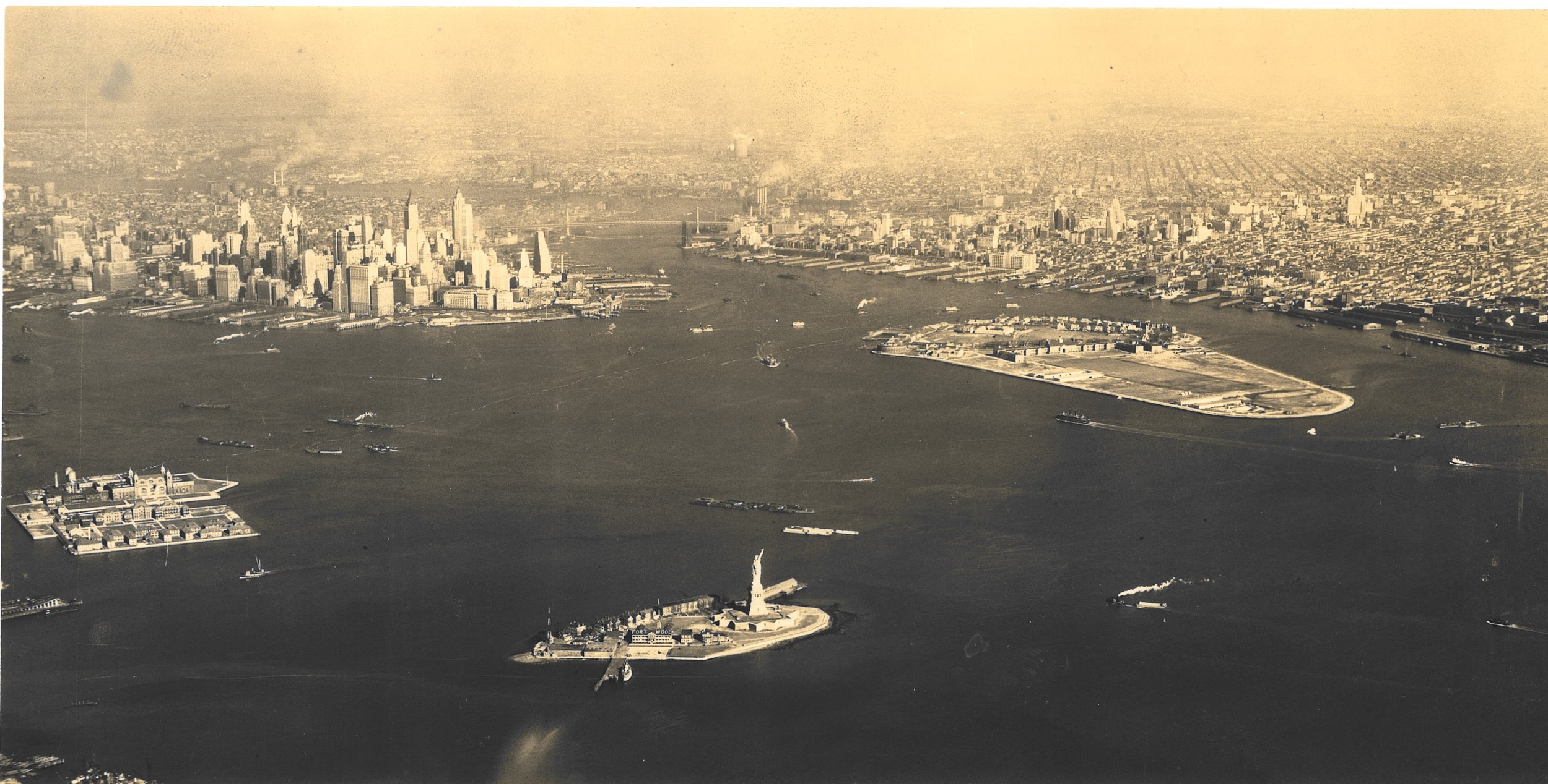
Aerial view New York Bay, Governor's Island, Statute of Liberty, Ellis Island, Manhattan and Brooklyn, ca. 1937. Photograph from 2nd Air Base Squadron Photo Section, GHQ Air Force, U.S. Army, Mitchel Field, New York, via WPA Federal Writers’ Project Photograph Collection. NYC Municipal Archives.

New York City is an archipelago of islands. New York harbor has 65 square miles of inland waterways and 772 miles of direct shoreline of which 580 miles surround the five Boroughs.   

The city’s waterways—rivers, bays and ocean—provided food for the indigenous population and early colonists. The deep ice-free waters of New York Harbor served as the basis for the city’s economic growth and development for more than three centuries. But there was a cost; the maritime activities that generated jobs and wealth, also created pollution that degraded marine life and cut off access to the waterfront. Policymakers focused on the condition of the harbor for decades.

The Department of Docks photograph collection includes numerous large-format glass-plate negatives dating from the 1870s that depict the commercial activity along both the East and North (Hudson) River waterfronts. West Street, ca. 1870. Department of Docks Collection. NYC Municipal Archives.

Government recognized that encroachments and waste in the harbor required control but faced challenges in regulating emissions and shoreline construction.

Beginning with the publication of Silent Spring by Rachel Carson in 1962, Americans began focusing on environmental issues. The Cuyahoga River famously caught fire in 1969 leading to the eventual passage of the federal Clean Water Act in 1972. By the 1970s, the city and surrounding communities began to address these concerns with an increased focus on eliminating the discharge of raw sewage and toxic waste into area waterways. Since then, many fish species have returned, and as commercial activities diminished, waterfronts have been reclaimed for housing, recreation and other activities.   

Graphic showing relationship between bathing beaches and sewage discharge from the Metropolitan Sewage Commission of New York’s 1912 report. NYC Municipal Library 

More recently, climate-change and the resulting superstorms and other destructive weather events have focused attention on the waterfront and the benefits of habitat restoration and stormwater management. The Municipal Archives and Library collections include extensive historical documentation of the waterfront that may prove useful in this essential work to create a more resilient New York and New Jersey harbor. 

The archival records date from the earliest years of the Department of Docks (1870– 1897); Docks and Ferries (1898 -1918); Department of Docks (1919-1942); Marine and Aviation (1942-1977); Ports and Terminals (1978-1985), through its final iteration, the Department of Ports and Trade (1986-1991). These series offer hundreds of cubic feet of maps, surveys, official correspondence and photographs. 

Illustration from the report, Present sanitary condition of New York Harbor and the degree of Cleanness which is necessary and sufficient for the water issued in 1912. NYC Municipal Library.

Publications in the Municipal Library document research developed by government agencies. The Metropolitan Sewage Commission of New York, issued several reports on water quality and pollutants in the Harbor beginning in 1910. More recently, the Department of Health issued Beach and Harbor Water Sampling reports that showed levels of contaminants at City beaches. In 1926, the Board of Estimate’ Subcommittee on Main Drainage issued a report on tidal currents in the Harbor, based on the movement of bottle floats.  

The theme of this year’s City of Water Day is to expand the capacity of New York and New Jersey communities to address climate change. Activities in the region include kayaking, rowing, hands-on workshops, and dozens of events for fun, education, and access to the waterfront. Visit the City of Water Day website for a complete calendar of events. 

In the meantime, here are some historical images of New York’s waterfront.  

The Department of Marine and Aviation collection includes large format color transparencies. Pier 40: Norwich and Stonington Lines (New England). Holland-American Lines (new Pier 40), circa 1960. Department of Ports and Trade Collection. NYC Municipal Archives.

Aerial view of the Brooklyn waterfront near Atlantic Avenue, September 19, 1956. Department of Marine and Aviation Collection. NYC Municipal Archives.

Aerial view of lower Manhattan, September 19, 1956. Department of Marine and Aviation Collection. NYC Municipal Archives. 

North River piers, Chelsea section, July 24, 1953. Department of Marine and Aviation Collection. NYC Municipal Archives. 

Barges, East River, June 30, 1938, Photographer: E.M.  Bofinger WPA Federal Writers’ Project Photograph Collection.
Spring 2020

New Yorkers look forward to the first day of Spring. Sometimes the weather cooperates, but even if it does not, it marks a period of beginnings, new growth and hope. 

But this is not an ordinary year. Like all New Yorkers at this time, everyone at the Municipal Archives is doing their best to stay safe and healthy.  Closing the public reading rooms was a regrettable, but necessary, step to help prevent the spread of the coronavirus. During this hiatus, many Municipal Archives staff are ‘teleworking’ and using this time to improve intellectual control over our vast collections. They are transcribing inventories, editing descriptive information, and writing finding guides. This important work will greatly add to the usefulness of ArchivesSpace, the on-line tool we will be launching in 2020 to provide on-line information about dozens of important collections.   

In the meantime, we can take this opportunity to remind our patrons and friends that there is already a great deal of content readily accessible on our website. In the online gallery there are now more than 1.5 million photographs, moving images, maps, architectural plans, and ledgers to view (and order if one catches your fancy). Patrons are also invited to visit Archives.NYC to read through our blogs, catch up on our prior exhibits and review the shared histories developed jointly by the Amsterdam Archives and the Municipal Archives.

The Central Park Lake, ca. 1936. WPA FWP Collection. NYC Municipal Archives

The Central Park Lake, ca. 1936. WPA FWP Collection. NYC Municipal Archives

Here are more evocative images taken by City and WPA photographers early in the spring season, many decades ago.

On an early spring day in 1938 WPA photographer, E. M. Bofinger traveled around the City documenting parks, people and iconic venues. Fort Tryon Park was one stop on his journey. The Cloisters are in the background. E. M. Bofinger, April 17, 1938. W…

On an early spring day in 1938 WPA photographer, E. M. Bofinger traveled around the City documenting parks, people and iconic venues. Fort Tryon Park was one stop on his journey. The Cloisters are in the background. E. M. Bofinger, April 17, 1938. WPA FWP Collection. NYC Municipal Archives

A view of the Hudson River from Fort Tryon Park, with the George Washington Bridge in the background. E. M. Bofinger, April 17, 1938. WPA FWP Collection. NYC Municipal Archives.

A view of the Hudson River from Fort Tryon Park, with the George Washington Bridge in the background. E. M. Bofinger, April 17, 1938. WPA FWP Collection. NYC Municipal Archives.

Drinking Fountain, Prospect Park, Brooklyn, April 17, 1938, E. M. Bofinger. WPA-FWP Collection. NYC Municipal Archives.

Drinking Fountain, Prospect Park, Brooklyn, April 17, 1938, E. M. Bofinger. WPA-FWP Collection. NYC Municipal Archives.

Bowling Green Park, from the steps of the Customs House, Lower Broadway, Manhattan. E. M. Bofinger, April 17, 1938. WPA FWP Collection. NYC Municipal Archives

Bowling Green Park, from the steps of the Customs House, Lower Broadway, Manhattan. E. M. Bofinger, April 17, 1938. WPA FWP Collection. NYC Municipal Archives

Times Square, April 17, 1938. E. M. Bofinger, WPA FWP Collection. NYC Municipal Archives.

Times Square, April 17, 1938. E. M. Bofinger, WPA FWP Collection. NYC Municipal Archives.

As we said, spring weather is unpredictable. On March 19, 1940, the temperatures jumped up to summer-time levels and everyone headed to the beach. Orchard Beach, Pelham Bay Park, Department of Parks Collection. NYC Municipal Archives.

As we said, spring weather is unpredictable. On March 19, 1940, the temperatures jumped up to summer-time levels and everyone headed to the beach. Orchard Beach, Pelham Bay Park, Department of Parks Collection. NYC Municipal Archives.

“The Heart of Chinatown,” 70 Mulberry Street

The recent fire at 70 Mulberry Street, home of many social service organizations and the research center for the Museum of Chinese in America (MOCA) destroyed a 130-year old building. Called the Heart of Chinatown not only because of the services provided there but because as a neighborhood school it had served the community for decades. When we stood outside the building in the aftermath of the fire, numerous older residents remarked to us, “I went to school there.”

PS 23 Manhattan, July 22, 1929. BOE 3276, NYC Board of Education Collection, NYC Municipal Archives.

As the home of New York City Government’s historical records, it seemed possible that the Municipal Archives held records depicting the neighborhood and the school. Indeed we do.

Bayard Street Elevation, 1891. Architect CBJ Snyder, NYC Board of Education Collection, NYC Municipal Archives.

The oldest record in the Municipal Archives pertaining to the building is the “Application for Erection of Buildings,” filed with the Department of Buildings in 1891. Submitted by prolific school architect Charles B. J. Snyder, the building was designed to serve as an elementary school, through grade 8, with 31 classrooms and a capacity of 1,694 students. The total cost of construction was $130,000. During his tenure from 1891 to 1922, Snyder designed more than 400 schools for New York City, the greatest expansion of public schools in American history. Snyder schools are noted for the abundance of natural light flowing into the classrooms through oversize windows.

Kindergarten Painter, PS 23, Manhattan, June 3, 1935. BOE 5489, NYC Board of Education Collection, NYC Municipal Archives.

Kindergarten Art Class, PS 23, Manhattan, June 3, 1935. BOE 5491, NYC Board of Education Collection, NYC Municipal Archives.

Arts and Crafts, PS 23, Manhattan, June 11, 1947. BOE 13010, NYC Board of Education Collection, NYC Municipal Archives.

Board of Education officials designated the building as Public School (P.S.) no. 23. In 1915, the Board decided to add “distinctive” names to many of the numbered schools. P.S. 23 became “The Columbus School,” in recognition of the then-predominantly Italian-American population it served at that time. By the 1930s, increased immigration from China was reflected in the student body. In the late 1940s, the school also served as a venue for adult-education programs designed to assist the many newcomers to the city.

Overcrowded class in English for Foreigners, PS 23, Manhattan, October 1, 1946. BOE 12294, NYC Board of Education Collection, NYC Municipal Archives.

English class with Chinese interpreter, PS 23, Manhattan, October 1, 1946. BOE 12293, NYC Board of Education Collection, NYC Municipal Archives.

Adult class in English, PS 23, Manhattan, May 13, 1952. BOE 20636, NYC Board of Education Collection, NYC Municipal Archives.

In June 1976, the building was de-commissioned as a school. The city maintained ownership however, and the building became the home for several community groups, including the Chinatown Manpower Project, which offers vocational training, employment services and educational programs; H.T. Chen and Dancers, a modern dance company; and the Chinese American Planning Council. It also houses collections and research materials from the Museum of Chinese in America.

The photographs illustrating this blog are part of the Municipal Archives’ Board of Education collection. Although the images are dated, the names of those depicted in the pictures were not recorded. If anyone recognizes a parent or grandparent or older neighbor in the photographs, please let us know so we can include their names in the historical record.

Powered by Squarespace